TR: McGee, Hopkins, Grinnell Lake, and smoke, 7/27/18-7/30/18
Posted: Sun Oct 14, 2018 10:08 am
This was my one backpack trip of the year, prompted by my son who had not been able to find the time for a trip for 7-8 years due to work and family responsibilities. But the stars aligned for him in late July and he was excited to be able to squeeze in a 3 night 4 day trip. There were a couple of aspects of the trip that were somewhat unusual and perhaps of interest, so here is a trip report.
I had reserved a permit out of Lake Sabrina, intending to go over Haeckel Col, which I have crossed a couple times in decades past, then back over Lamarck Col to North Lake. But a rockslide closed the road up to Lake Sabrina a few days before our trip, and all other trailheads of interest were fully reserved. So we decided to take our chances for a walk up permit. With a late start from Berkeley, we didn’t arrive at the Lee Vining permit desk until early afternoon on a Friday, and it was quite smoky from the Ferguson fire and other fires around the state. I was not optimistic about getting a permit for a Friday entry in peak summer season. Surprisingly there was space available for two at the McGee Creek trailhead, so we took that. The smoky conditions probably had resulted in some permit cancellations. We were set on going despite the smoke.
The itinerary I decided on from McGee Creek was identical to a trip I had done myself 15 years earlier, which was to circumnavigate Red and White Mountain and its immediate neighboring peaks, over Hopkins Pass and back over McGee Pass, with highlights being Laurel Creek, Grinnell Lake, and the pond-dotted environs west of Red and White Mountain.
By the time we hit the trail it was nearly 3pm. Lack of acclimatization, lack of pre-trip conditioning, excess weight, age, and probably the smoke made the first several miles a major challenge for me. But I willed myself up to Big McGee Lake, where we arrived around sunset. It was quite smoky.
Fortunately the next morning was clear, and I felt much better. My son commandeered my camera the entire trip, and he enjoyed playing around with the panorama mode.
Heading up from Big McGee Lake toward Hopkins Pass, flowers were still prolific in wetter areas.
Another panorama, looking north from Hopkins Pass. I considered telling my son that we would be returning over McGee Pass to the right of this view in three days time, but thought it better not to, lest I be accused of planning yet another marathon trip.
At Hopkins Pass we met the only other hikers we would see until three days later down below Big McGee Lake. I shared my trip plan, which was to descend to Mono Creek and ascend steeply back up to Laurel Creek, then gradually up to Laurel Lake and Grinnell Lake. This couple was a husband and wife from Bishop, veteran hikers themselves. The husband suggested that we consider going cross country over “Grinnell Col” and he pointed to a saddle on the ridge. He had not done that route himself, but had thought it looked like a reasonable route. I remembered looking at that ridge from Grinnell Lake 15 years ago and wondering if there was a shortcut over it from the Hopkins Creek area to Grinnell Lake. So I decided we would give it a try, even though it would mean foregoing the lovely walk up Laurel Creek to Laurel Lake, which was a favorite area of mine, among many favorites.
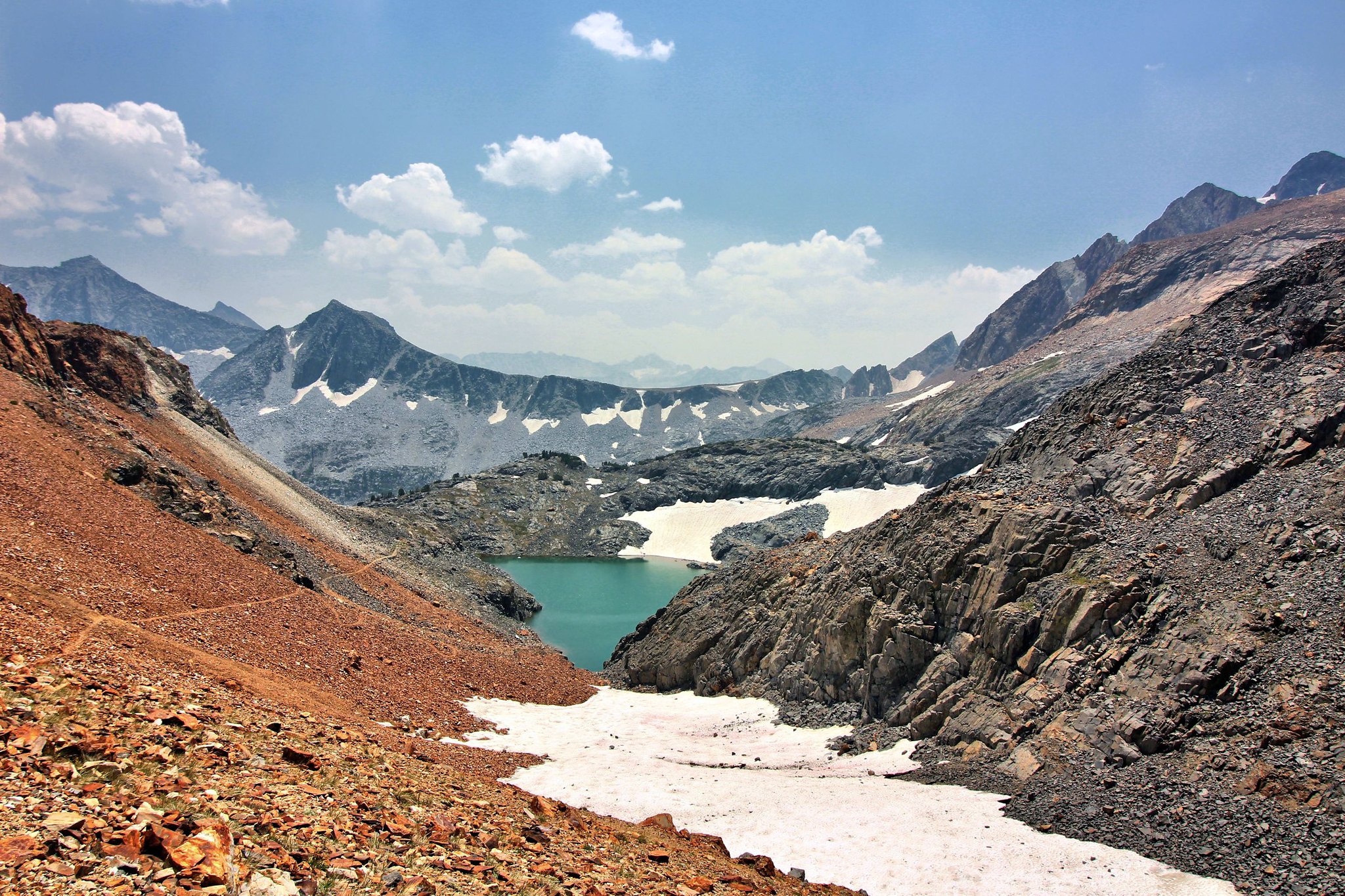
The ascent up to the saddle from Upper Hopkins Lake was not difficult. At the saddle I was greeted with a south-facing view of the shoreline along two of the three lobes of Grinnell Lake, and of the smoke that was again rising from the fires to the west.
I had anticipated seeing a route around the lake along the eastern shoreline, but that did not appear to be the case. I knew that there was no route around the other side of the lake below Red and White Mountain. (Out of curiosity I did some research later, and learned that the actual crossing from Grinnell Lake to Hopkins basin is from the peninsula on the eastern shore up to the saddle on the ridge above the peninsula.) Anyway, we decided to descend to the lake and see what it looked like. The initial descent was sliding and plunging through very loose gravelly rock. Halfway down we contoured west onto firm rock and were able to pick a scrambling route down to the large flat peninsula on the northeast side of the lake.
The next morning.
We wished we could have had a layover day here to relax and enjoy the peaceful solitude of this beautiful place. But we needed to get our gear across the lake. We inflated our two sleeping pads and put them inside one of our bivy sacks, along with a fully extended lightweight tripod for extra rigidity. It took three trips across and back the roughly 40 yards at the narrowest point between lobes to get all of our gear across. Here’s a self timer shot with smudge on the lens and hiking pole handle.
A couple of gallons of water seeped in and got the sleeping pads wet, but they dried quickly in the warm sun. We decided that this could be an excellent method for providing a shortcut across a body of water if necessary in midseason when the water temperature is tolerable. We also remarked that multi-lobed Grinnell Lake would be wonderful to explore on a raft, if only there were one lightweight enough to carry backpacking.
I had reserved a permit out of Lake Sabrina, intending to go over Haeckel Col, which I have crossed a couple times in decades past, then back over Lamarck Col to North Lake. But a rockslide closed the road up to Lake Sabrina a few days before our trip, and all other trailheads of interest were fully reserved. So we decided to take our chances for a walk up permit. With a late start from Berkeley, we didn’t arrive at the Lee Vining permit desk until early afternoon on a Friday, and it was quite smoky from the Ferguson fire and other fires around the state. I was not optimistic about getting a permit for a Friday entry in peak summer season. Surprisingly there was space available for two at the McGee Creek trailhead, so we took that. The smoky conditions probably had resulted in some permit cancellations. We were set on going despite the smoke.
The itinerary I decided on from McGee Creek was identical to a trip I had done myself 15 years earlier, which was to circumnavigate Red and White Mountain and its immediate neighboring peaks, over Hopkins Pass and back over McGee Pass, with highlights being Laurel Creek, Grinnell Lake, and the pond-dotted environs west of Red and White Mountain.
By the time we hit the trail it was nearly 3pm. Lack of acclimatization, lack of pre-trip conditioning, excess weight, age, and probably the smoke made the first several miles a major challenge for me. But I willed myself up to Big McGee Lake, where we arrived around sunset. It was quite smoky.
Fortunately the next morning was clear, and I felt much better. My son commandeered my camera the entire trip, and he enjoyed playing around with the panorama mode.
Heading up from Big McGee Lake toward Hopkins Pass, flowers were still prolific in wetter areas.
Another panorama, looking north from Hopkins Pass. I considered telling my son that we would be returning over McGee Pass to the right of this view in three days time, but thought it better not to, lest I be accused of planning yet another marathon trip.
At Hopkins Pass we met the only other hikers we would see until three days later down below Big McGee Lake. I shared my trip plan, which was to descend to Mono Creek and ascend steeply back up to Laurel Creek, then gradually up to Laurel Lake and Grinnell Lake. This couple was a husband and wife from Bishop, veteran hikers themselves. The husband suggested that we consider going cross country over “Grinnell Col” and he pointed to a saddle on the ridge. He had not done that route himself, but had thought it looked like a reasonable route. I remembered looking at that ridge from Grinnell Lake 15 years ago and wondering if there was a shortcut over it from the Hopkins Creek area to Grinnell Lake. So I decided we would give it a try, even though it would mean foregoing the lovely walk up Laurel Creek to Laurel Lake, which was a favorite area of mine, among many favorites.
The ascent up to the saddle from Upper Hopkins Lake was not difficult. At the saddle I was greeted with a south-facing view of the shoreline along two of the three lobes of Grinnell Lake, and of the smoke that was again rising from the fires to the west.
I had anticipated seeing a route around the lake along the eastern shoreline, but that did not appear to be the case. I knew that there was no route around the other side of the lake below Red and White Mountain. (Out of curiosity I did some research later, and learned that the actual crossing from Grinnell Lake to Hopkins basin is from the peninsula on the eastern shore up to the saddle on the ridge above the peninsula.) Anyway, we decided to descend to the lake and see what it looked like. The initial descent was sliding and plunging through very loose gravelly rock. Halfway down we contoured west onto firm rock and were able to pick a scrambling route down to the large flat peninsula on the northeast side of the lake.
The next morning.
We wished we could have had a layover day here to relax and enjoy the peaceful solitude of this beautiful place. But we needed to get our gear across the lake. We inflated our two sleeping pads and put them inside one of our bivy sacks, along with a fully extended lightweight tripod for extra rigidity. It took three trips across and back the roughly 40 yards at the narrowest point between lobes to get all of our gear across. Here’s a self timer shot with smudge on the lens and hiking pole handle.
A couple of gallons of water seeped in and got the sleeping pads wet, but they dried quickly in the warm sun. We decided that this could be an excellent method for providing a shortcut across a body of water if necessary in midseason when the water temperature is tolerable. We also remarked that multi-lobed Grinnell Lake would be wonderful to explore on a raft, if only there were one lightweight enough to carry backpacking.