Trip planning: Red Mountain Basin & Martha Lake in July

If you've been searching for the best source of information and stimulating discussion related to Spring/Summer/Fall backpacking, hiking and camping in the Sierra Nevada...look no further!
User avatar
sekihiker
Founding Member
Posts: 958
Joined: Sun Dec 18, 2005 2:47 pm
Experience: Level 4 Explorer
Location: Fresno
Contact:

Re: Trip planning: Red Mountain Basin & Martha Lake in July

Post by sekihiker »

grampy wrote: Sun May 03, 2020 8:06 pm Given my respect for your collective experience, I’ll likely scale plans back to a “R.M.Basin-only” itinerary.
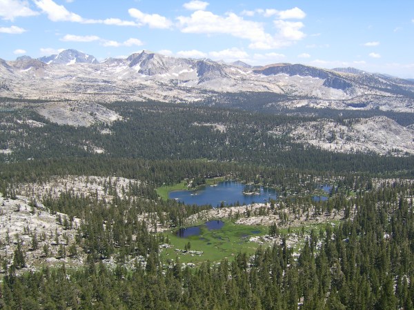
Visiting every lake in the Red Mountain Basin is a worthwhile trip in itself. A hike to the top of Hell For Sure Pass or Mt Hutton gives you a great view of the higher alpine lakes. The view from Fleming Mountain, an easy hike from Rae Lake (below), gives another perspective of the western part of the basin and a peek into the seldom visited headwaters of Post Corral Creek (not shown to the west).
Image
Mt Goddard, Mt Hutton and the Red Mountain Basin from Fleming Mountain.
User avatar
jmherrell
Topix Acquainted
Posts: 70
Joined: Sun Jun 10, 2012 2:41 pm
Experience: N/A

Re: Trip planning: Red Mountain Basin & Martha Lake in July

Post by jmherrell »

One more comment on the ponds on the ridge (on the map) about 2 miles before Fleming Lake. I also stopped there on the first night mid summer thinking I could get water knowing that it would be low quality. They were totally dry. I ended up hiking down to Fleming Creek to get water and back to camp in the dark, not fun.

If you do dayhike the pass, Red Mountain is an even better view and is an easy walkup from the pass.
User avatar
grampy
Topix Regular
Posts: 398
Joined: Tue May 15, 2018 10:45 am
Experience: Level 3 Backpacker
Location: Redondo Beach

Re: Trip planning: Red Mountain Basin & Martha Lake in July

Post by grampy »

Thank you, Bill and jm , for your input.
Yes, the water situation now has me planning night 1 at PCC , with night 2 at Rae or Lower Indian Lake. I may consider Bill’s suggested side-trip up Fleming Mountain if camped at Rae. I’m thinking of touring generally clockwise around the basin lakes from there; maybe Davis, Dale, Disappointment, Hell for Sure lakes; day hike to top of the pass (and Red Mountain - if I’m feeling strong), continuing on (skipping Arctic and maybe Horseshoe) to 3-4 more lakes before heading to exit. It’s feeling like a more reasonable & less-exhausting plan now.
User avatar
Wandering Daisy
Topix Docent
Posts: 6689
Joined: Sun Jan 24, 2010 8:19 pm
Experience: N/A
Location: Fair Oaks CA (Sacramento area)
Contact:

Re: Trip planning: Red Mountain Basin & Martha Lake in July

Post by Wandering Daisy »

In my opinion, Horseshoe Lake, Blackrock, the Shot Lakes and Devils Punchbowl are the most scenic lakes; Arctic not so much. Hell for Sure also good, but it is quite stark and windy to camp. I was much less impressed with the lakes to the north. However, if you are fishing, perhaps they are worthwhile. The off-trail lakes north of Hell for Sure and east of the trail up to Indian Lake are nice but not that impressive. I walked through them on the way to Mosquito Pass and then on down to Flemming Lake where I camped, not that it was great, but that is where I ended up at dark. It is a small basin and you can cover a lot of ground in a day.
User avatar
CarlRaillard
Topix Acquainted
Posts: 29
Joined: Wed Apr 29, 2020 7:54 pm
Experience: Level 4 Explorer

Re: Trip planning: Red Mountain Basin & Martha Lake in July

Post by CarlRaillard »

Disappointment Lake and Hell for Sure Pass are, perhaps, the two most incorrectly named features in the Sierra Nevada.

Sincerely,
Carl Raillard
Fun drawings of wild country.
User avatar
sekihiker
Founding Member
Posts: 958
Joined: Sun Dec 18, 2005 2:47 pm
Experience: Level 4 Explorer
Location: Fresno
Contact:

Re: Trip planning: Red Mountain Basin & Martha Lake in July

Post by sekihiker »

CarlRaillard wrote: Fri May 15, 2020 12:36 am Disappointment Lake and Hell for Sure Pass are, perhaps, the two most incorrectly named features in the Sierra Nevada.
I'm in 100% agreement!
User avatar
tlsharb
Topix Regular
Posts: 211
Joined: Tue Aug 20, 2013 11:05 am
Experience: Level 3 Backpacker

Re: Trip planning: Red Mountain Basin & Martha Lake in July

Post by tlsharb »

Semi-disagree: hell for sure from the west is not much, but from the east... that's a different story.
User avatar
sekihiker
Founding Member
Posts: 958
Joined: Sun Dec 18, 2005 2:47 pm
Experience: Level 4 Explorer
Location: Fresno
Contact:

Re: Trip planning: Red Mountain Basin & Martha Lake in July

Post by sekihiker »

tlsharb wrote: Fri May 15, 2020 3:07 pm Semi-disagree: hell for sure from the west is not much, but from the east... that's a different story.
I guess it's all relative. I've seen the original route from the east which switchbacked straight up the wall from the bottom of Goddard Canyon and that looks so daunting that the new route looks easy.
User avatar
tlsharb
Topix Regular
Posts: 211
Joined: Tue Aug 20, 2013 11:05 am
Experience: Level 3 Backpacker

Re: Trip planning: Red Mountain Basin & Martha Lake in July

Post by tlsharb »

Where would you get a look at the original route? I'd love t see it.
User avatar
sekihiker
Founding Member
Posts: 958
Joined: Sun Dec 18, 2005 2:47 pm
Experience: Level 4 Explorer
Location: Fresno
Contact:

Re: Trip planning: Red Mountain Basin & Martha Lake in July

Post by sekihiker »

tlsharb wrote: Fri May 15, 2020 6:35 pm Where would you get a look at the original route? I'd love t see it.
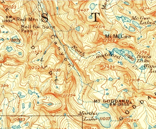
On the old Mount Goddard 30 minute quad of 1912, Hell for Pass trail reaches Goddard Canyon floor directly east of Red Mountain at an elevation of 9,400 feet in about 1.7 miles. The new trail reaches the canyon floor almost two miles south of there and at an elevation of about 9,900 feet in about 3.7 miles.

Old trail 11,279ft - 9,400ft / 1.7 miles = 1879ft/1.7mile = 1,105 ft/mile

New trail 11,279ft - 9,900ft / 3.7 miles = 1379ft/3.7miles = 373 ft/mile

Elevations and distances calculated on the 1999 version of TOPO!
Image

By the way, the switchbacks start on the west side of the pass at 10,560 and reach the pass in 0.62 miles.

West side trail 11,279ft - 10,560ft/ 0.62 miles = 719 ft/0.62mile = 1,160 ft/mile

The calculations for the east side don't take into account that most of the new trail on the east side is fairly flat.

Here is the calculation for the steepness for the east side trail before it turns south on the long, easy, new section of trail.
11,279ft - 10,144ft/ 1.2 miles = 1,135ft/ 1.2 miles = 946ft/mile

So the steepest part of the east side trail is actually easier than the steepest part of the west side trail.

Go figure.
Post Reply

Who is online

Users browsing this forum: No registered users and 350 guests