Corridor Pass
Posted: Thu Jul 16, 2015 4:05 pm
Corridor Pass
General Overview: This pass leads between upper McGee Creek to upper Convict Creek.
Difficulty: Class 2
Location: John Muir Wilderness, Inyo Forest. 0.6 miles NE of McGee Pass
Elevation: 11,800
USGS 7.5-minute topo: Convict Lake | See it on the HST Map
[rimg]http://i249.photobucket.com/albums/gg23 ... 20Pass.jpg[/rimg]
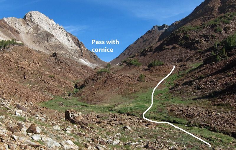
Route Description: Leave the Mc Gee Pass Trail about the second switchback after the grassy meadow where use-trails drop to camping areas on the west shore of Big Mc Gee Lake (about 10720). There is a faint use trail. Go up the drainage and over a small saddle and drop about 50 feet into the next drainage. Cross the creek and head up this drainage on the northeast side.
[rimg]http://i249.photobucket.com/albums/gg23 ... _route.jpg[/rimg]
At about 11,100 the drainage enters a slot. You can either stay on the northeast side and to up steep slope with some talus or cross the creek and go up over the buttress that forms the southwest wall of the slot. You then enter a lush upper valley and you can see the pass (often has a snow cornice).
Go to the northeast side of the creek and continue up until you reach an upper rock-studded flat (about 11,400) where there will be shallow melt water early season. The shallow ridge to the left has less talus. You hit the headwall (moraine) at about 11,500 feet. Go over to the northeast side to and up the drainage to avoid more complex series of lateral and medial moraines. You may have go around the cornice at the top. The south side is mostly Class 1 with easy Class 2 at the top couple hundred feet. The top is a flat saddle.
[rimg]http://i249.photobucket.com/albums/gg23 ... 20side.jpg[/rimg]
The north side is more difficult. (The upper steep snowfield does not show up in the photo above) You have to descend a series of terminal moraines with some steep and loose talus. Stay on the right (northeast) side descending. The upper snow gully is quite steep and if icy, you may have to stay on the rock which is steep and a bit unstable. After about 120 feet descent you are in a relatively flat jumble mess of talus of the upper moraine. Get to the north side. Here there often is a second snow gully. If the snow is too icy, you can go off the nose of the moraine or go along the side of the snow. The snow gullies are fairly small, but you it may still be beneficial to take microspikes or crampons, or wait until afternoon when the snow is softer.
[rimg]http://i249.photobucket.com/albums/gg23 ... de%202.jpg[/rimg]
[rimg]http://i249.photobucket.com/albums/gg23 ... ited-1.jpg[/rimg]
Continue down moderately sloped talus to a small flat (about 11,250) where there is a melt-stream and some grass. Drop down the steep slope into the prominent gully to the southwest. There are a few use-trails that go down this slope. It is steep and rocky mixed with grass. At the bottom you will be in a V-shaped slot that opens to a small pond. Go around either side of the pond. The easier route to continue is to climb up slightly over a shoulder, to a sandy flat. Follow this flat. It then gradually drops. There is a flood/mud slide gully that looks like a washed out trail. But a better route is to switchback left (south) and then north to get to the flatter ground. It is now a short distance to the inlet pond of Constance Lake.
You can go around either side of Constance Lake. The route around the east shore goes back up onto the ridge. Drop to the lake shore a bit more than half way to the outlet. There is a faint use-trail. A better use-trail then runs along the lake right at the water level, to the grassy outlet.
To go around the west side, you have to cross at the inlet pond, go over a buttress, and drop closer to the shore. There is a slot with a waterfall from the inlet pond to the lake. The south portion is rocky and you have to go up a few buttresses. Although shorter, this route is not suitable immediately after a rain, since debris comes off of Red Slate Mountain. About half way down the lake it becomes an easy walk on grass, with a use-trail.
General Overview: This pass leads between upper McGee Creek to upper Convict Creek.
Difficulty: Class 2
Location: John Muir Wilderness, Inyo Forest. 0.6 miles NE of McGee Pass
Elevation: 11,800
USGS 7.5-minute topo: Convict Lake | See it on the HST Map
[rimg]http://i249.photobucket.com/albums/gg23 ... 20Pass.jpg[/rimg]
![[rimg]http://i249.photobucket.com/albums/gg23 ... 20Pass.jpg[/rimg]](http://s249.photobucket.com/user/npallister/media/1015%20McGee-Convict/Corridoor%20Pass.jpg.html)
Route Description: Leave the Mc Gee Pass Trail about the second switchback after the grassy meadow where use-trails drop to camping areas on the west shore of Big Mc Gee Lake (about 10720). There is a faint use trail. Go up the drainage and over a small saddle and drop about 50 feet into the next drainage. Cross the creek and head up this drainage on the northeast side.
[rimg]http://i249.photobucket.com/albums/gg23 ... _route.jpg[/rimg]
![[rimg]http://i249.photobucket.com/albums/gg23 ... _route.jpg[/rimg]](http://s249.photobucket.com/user/npallister/media/1015%20McGee-Convict/1624_Creek%20at%20Corrd%20Pass_south%20side_route.jpg.html)
At about 11,100 the drainage enters a slot. You can either stay on the northeast side and to up steep slope with some talus or cross the creek and go up over the buttress that forms the southwest wall of the slot. You then enter a lush upper valley and you can see the pass (often has a snow cornice).

Go to the northeast side of the creek and continue up until you reach an upper rock-studded flat (about 11,400) where there will be shallow melt water early season. The shallow ridge to the left has less talus. You hit the headwall (moraine) at about 11,500 feet. Go over to the northeast side to and up the drainage to avoid more complex series of lateral and medial moraines. You may have go around the cornice at the top. The south side is mostly Class 1 with easy Class 2 at the top couple hundred feet. The top is a flat saddle.
[rimg]http://i249.photobucket.com/albums/gg23 ... 20side.jpg[/rimg]
![[rimg]http://i249.photobucket.com/albums/gg23 ... 20side.jpg[/rimg]](http://s249.photobucket.com/user/npallister/media/1015%20McGee-Convict/1492_Corridoor%20Pass%20Route%20north%20side.jpg.html)
The north side is more difficult. (The upper steep snowfield does not show up in the photo above) You have to descend a series of terminal moraines with some steep and loose talus. Stay on the right (northeast) side descending. The upper snow gully is quite steep and if icy, you may have to stay on the rock which is steep and a bit unstable. After about 120 feet descent you are in a relatively flat jumble mess of talus of the upper moraine. Get to the north side. Here there often is a second snow gully. If the snow is too icy, you can go off the nose of the moraine or go along the side of the snow. The snow gullies are fairly small, but you it may still be beneficial to take microspikes or crampons, or wait until afternoon when the snow is softer.
[rimg]http://i249.photobucket.com/albums/gg23 ... de%202.jpg[/rimg]
![[rimg]http://i249.photobucket.com/albums/gg23 ... de%202.jpg[/rimg]](http://s249.photobucket.com/user/npallister/media/1015%20McGee-Convict/1495_Cooridor%20Pass_north%20side%202.jpg.html)
[rimg]http://i249.photobucket.com/albums/gg23 ... ited-1.jpg[/rimg]
![[rimg]http://i249.photobucket.com/albums/gg23 ... ited-1.jpg[/rimg]](http://s249.photobucket.com/user/npallister/media/1015%20McGee-Convict/1618_N%20side%20CorrdPass_edited-1.jpg.html)
Continue down moderately sloped talus to a small flat (about 11,250) where there is a melt-stream and some grass. Drop down the steep slope into the prominent gully to the southwest. There are a few use-trails that go down this slope. It is steep and rocky mixed with grass. At the bottom you will be in a V-shaped slot that opens to a small pond. Go around either side of the pond. The easier route to continue is to climb up slightly over a shoulder, to a sandy flat. Follow this flat. It then gradually drops. There is a flood/mud slide gully that looks like a washed out trail. But a better route is to switchback left (south) and then north to get to the flatter ground. It is now a short distance to the inlet pond of Constance Lake.
You can go around either side of Constance Lake. The route around the east shore goes back up onto the ridge. Drop to the lake shore a bit more than half way to the outlet. There is a faint use-trail. A better use-trail then runs along the lake right at the water level, to the grassy outlet.
To go around the west side, you have to cross at the inlet pond, go over a buttress, and drop closer to the shore. There is a slot with a waterfall from the inlet pond to the lake. The south portion is rocky and you have to go up a few buttresses. Although shorter, this route is not suitable immediately after a rain, since debris comes off of Red Slate Mountain. About half way down the lake it becomes an easy walk on grass, with a use-trail.
![[rimg]http://i249.photobucket.com/albums/gg23 ... 0route.jpg[/rimg]](http://s249.photobucket.com/user/npallister/media/1015%20McGee-Convict/1594_ALT_East%20shore%20Constance%20route.jpg.html)
![[rimg]http://i249.photobucket.com/albums/gg23 ... 0route.jpg[/rimg]](http://s249.photobucket.com/user/npallister/media/1015%20McGee-Convict/1497_Constance%20west%20shore%20route.jpg.html)