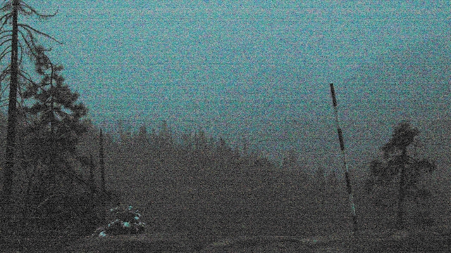
Hi Paloma,
Here is a current webcam shots from Hume Lake and the Giant Forest in SEKI, the conditions look horrible:
http://humewebcams.s3.amazonaws.com/lake/latest.jpg
https://www.nps.gov/featurecontent/ard/ ... 9577329261
2020 Fire/Smoke Impact Reports
-
maverick

- Forums Moderator

- Posts: 11837
- Joined: Thu Apr 06, 2006 5:54 pm
- Experience: Level 4 Explorer
Re: 2020 Fire/Smoke Impact Reports
Professional Sierra Landscape Photographer
I don't give out specific route information, my belief is that it takes away from the whole adventure spirit of a trip, if you need every inch planned out, you'll have to get that from someone else.
Have a safer backcountry experience by using the HST ReConn Form 2.0, named after Larry Conn, a HST member: http://reconn.org
-
c9h13no3

- Topix Fanatic
- Posts: 1326
- Joined: Tue Sep 18, 2018 1:19 pm
- Experience: Level 1 Hiker
- Location: San Mateo, CA
Re: 2020 Fire/Smoke Impact Reports
If you'd leave Washington state to come down here, you're going the exact wrong direction. Your friend sucks at trip planning.
Also, palomas are delicious
"Adventure is just bad planning." - Roald Amundsen
Also, I have a blog no one reads. Please do not click here.
Also, I have a blog no one reads. Please do not click here.
-
Paloma

- Topix Novice
- Posts: 12
- Joined: Mon Sep 26, 2016 10:50 am
- Experience: Level 3 Backpacker
Re: 2020 Fire/Smoke Impact Reports
Lol, Paloma is my dog. She is a beautiful white german shepherd. I’ve never heard of this drink. My friend is nuts! He got an email from whatever agency issued his permit and they didn’t say not to come, just something about only using trails into and out of The National Park and not the forest lands that were closed yesterday.
-
schmalz
- Topix Expert
- Posts: 588
- Joined: Fri May 07, 2010 9:18 am
- Experience: Level 4 Explorer
- Location: Altadena, CA
- Contact:
Re: 2020 Fire/Smoke Impact Reports
Wow your friend is in for a rude awakening upon arriving to Norcal/Kings Canyon.
http://CaliTrails.com" onclick="window.open(this.href);return false;
http://facebook.com/calitrails" onclick="window.open(this.href);return false;
http://facebook.com/calitrails" onclick="window.open(this.href);return false;
-
Paloma
- Topix Novice
- Posts: 12
- Joined: Mon Sep 26, 2016 10:50 am
- Experience: Level 3 Backpacker
Re: 2020 Fire/Smoke Impact Reports
I would have thought that the agency that gave him
His permit would have revoked it but they must be letting people into the park which seems iffy. The weather forecast keeps saying clear skies for Cedar Grove for the next 10 days. I don’t see how that’s possible. We have smoke in Seattle today but that’s probably from fires in WA.
His permit would have revoked it but they must be letting people into the park which seems iffy. The weather forecast keeps saying clear skies for Cedar Grove for the next 10 days. I don’t see how that’s possible. We have smoke in Seattle today but that’s probably from fires in WA.
-
owen
- Topix Novice
- Posts: 10
- Joined: Mon Jun 29, 2020 10:19 am
- Experience: Level 3 Backpacker
- Location: Alameda, CA
Re: 2020 Fire/Smoke Impact Reports
Definitely not clear skies. Check out this map. Dude should cancel that trip.
https://gispub.epa.gov/airnow/?campaign ... 011d1baa44
Also the fire is fast moving, strong winds are in the forecast. Just because you can enter Kings Canyon today doesn't mean that will be true tomorrow. It's not going to get any better anytime soon.
https://gispub.epa.gov/airnow/?campaign ... 011d1baa44
Also the fire is fast moving, strong winds are in the forecast. Just because you can enter Kings Canyon today doesn't mean that will be true tomorrow. It's not going to get any better anytime soon.
-
SSSdave
- Topix Addict
- Posts: 3524
- Joined: Thu Nov 17, 2005 11:18 pm
- Experience: N/A
- Location: Silicon Valley
- Contact:
Re: 2020 Fire/Smoke Impact Reports
Creek Fire becomes ‘unprecedented disaster’ for Fresno County as it grows to 135,500 acres. (210 square miles)
https://www.fresnobee.com/news/californ ... 55265.html
Created below map in Photoshop this morning from an online UCCE page. Now threatening a lot of lower elevation zones where people have homes.
https://www.fresnobee.com/news/californ ... 55265.html
Created below map in Photoshop this morning from an online UCCE page. Now threatening a lot of lower elevation zones where people have homes.
You do not have the required permissions to view the files attached to this post.
-
schmalz
- Topix Expert
- Posts: 588
- Joined: Fri May 07, 2010 9:18 am
- Experience: Level 4 Explorer
- Location: Altadena, CA
- Contact:
Re: 2020 Fire/Smoke Impact Reports
I hate to say it, but I'm glad it's heading to lower elevations instead of ripping through the wilderness to the East.
Hopefully we can start getting more resources allocated to proactive fire management, more controlled burns etc.
Hopefully we can start getting more resources allocated to proactive fire management, more controlled burns etc.
http://CaliTrails.com" onclick="window.open(this.href);return false;
http://facebook.com/calitrails" onclick="window.open(this.href);return false;
http://facebook.com/calitrails" onclick="window.open(this.href);return false;
-
c9h13no3
- Topix Fanatic
- Posts: 1326
- Joined: Tue Sep 18, 2018 1:19 pm
- Experience: Level 1 Hiker
- Location: San Mateo, CA
Re: 2020 Fire/Smoke Impact Reports
Not to derail things, but controlled burns are tough. If you light a controlled fire and it gets out of hand, the Forest Service is liable for the damage. If lightning sets a fire, and it wipes out the community, Forest Service doesn't pay a dime. The incentives are all messed up.
"Adventure is just bad planning." - Roald Amundsen
Also, I have a blog no one reads. Please do not click here.
Also, I have a blog no one reads. Please do not click here.
-
rlown

- Topix Docent
- Posts: 8225
- Joined: Thu Oct 25, 2007 5:00 pm
- Experience: Level 4 Explorer
- Location: Wilton, CA
Re: 2020 Fire/Smoke Impact Reports
Hmmm. I remember Yose doing them all the time, just to clear the underbrush..
Still would be a better option than what is being done now.
And, bring back logging. Loggers seem to do a good job at thinning and underbrush clearing.
Still would be a better option than what is being done now.
And, bring back logging. Loggers seem to do a good job at thinning and underbrush clearing.
Who is online
Users browsing this forum: No registered users and 205 guests