Anything could help, thank you. One of the moderators on the Rock Creek message board lives in the area, she was planning to go to the area this weekend, maybe she will have something to post later on.I know it's a long shot, but here's a 360 panorama I shot on my last trip in 2014.
Missing Hiker and Dog near Donner Pass
-
maverick

- Forums Moderator

- Posts: 11835
- Joined: Thu Apr 06, 2006 5:54 pm
- Experience: Level 4 Explorer
Re: Missing Hiker and Dog near Donner Pass
Professional Sierra Landscape Photographer
I don't give out specific route information, my belief is that it takes away from the whole adventure spirit of a trip, if you need every inch planned out, you'll have to get that from someone else.
Have a safer backcountry experience by using the HST ReConn Form 2.0, named after Larry Conn, a HST member: http://reconn.org
-
fishwrong

- Topix Regular
- Posts: 118
- Joined: Fri Oct 22, 2010 9:14 pm
- Experience: N/A
Re: Missing Hiker and Dog near Donner Pass
Thank you for the panorama video. Looks like it could be close to the same location. I didn't notice flowing water in the video, but sounds like it in the audio. Could be the stove, not sure.
Please send the panorama to Placer County, and it may be of help.
Thank you.
Please send the panorama to Placer County, and it may be of help.
Thank you.
-
maverick
- Forums Moderator
- Posts: 11835
- Joined: Thu Apr 06, 2006 5:54 pm
- Experience: Level 4 Explorer
Re: Missing Hiker and Dog near Donner Pass
Expand the view and concentrate on the water water section only at .29, there is a very slight movement in it.I didn't notice flowing water in the video, but sounds like it in the audio. Could be the stove, not sure.
Professional Sierra Landscape Photographer
I don't give out specific route information, my belief is that it takes away from the whole adventure spirit of a trip, if you need every inch planned out, you'll have to get that from someone else.
Have a safer backcountry experience by using the HST ReConn Form 2.0, named after Larry Conn, a HST member: http://reconn.org
I don't give out specific route information, my belief is that it takes away from the whole adventure spirit of a trip, if you need every inch planned out, you'll have to get that from someone else.
Have a safer backcountry experience by using the HST ReConn Form 2.0, named after Larry Conn, a HST member: http://reconn.org
-
Brien
- Topix Acquainted
- Posts: 77
- Joined: Sat Jun 29, 2013 10:41 pm
- Experience: N/A
- Location: Sacramento, CA
Re: Missing Hiker and Dog near Donner Pass
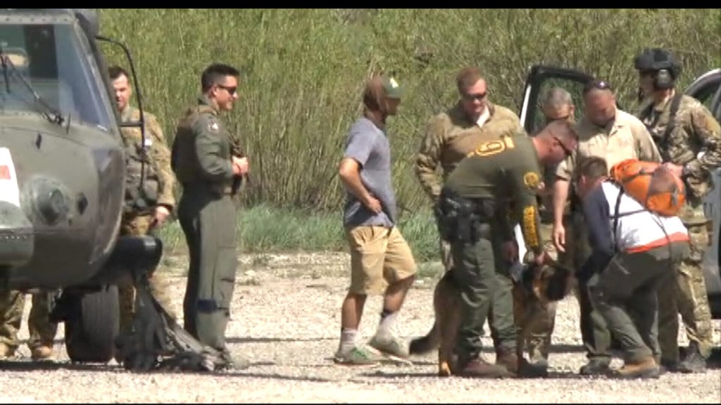
Cody has been found with his dog alive.
-
FeetFirst

- Topix Regular
- Posts: 304
- Joined: Fri Apr 22, 2011 11:35 am
- Experience: Level 4 Explorer
- Location: West Sacramento, CA
- Contact:
Re: Missing Hiker and Dog near Donner Pass
April 14, 2014 day scouting trip. I turned around and headed back before reaching the lakes (probably around 6,500'): https://goo.gl/photos/i8iioZYkBFaDLu4n6maverick wrote:If anyone has any pictures/videos taken during early season of the Loch Leven Lakes area, they could be very useful in narrowing down the possible location this video clip may have been taken.
Your help is appreciated! Thank you
***Edit*** Sorry, I posted this before reaching the end of the thread and the GREAT news!
Last edited by FeetFirst on Thu May 19, 2016 11:08 am, edited 1 time in total.
I'm still rather convinced that you can achieve more than you've ever dreamed of if you just lower your standards.
-
zacjust32

- Topix Regular
- Posts: 362
- Joined: Thu Apr 16, 2015 12:50 pm
- Experience: Level 3 Backpacker
- Location: Fresno, Ca
- Contact:
Re: Missing Hiker and Dog near Donner Pass
That's good news, looking forward to hearing his account.
-
TahoeJeff

- Topix Fanatic
- Posts: 1224
- Joined: Thu Mar 08, 2007 11:03 am
- Experience: Level 3 Backpacker
- Location: South Lake Tahoe, NV
Re: Missing Hiker and Dog near Donner Pass
+1zacjust32 wrote:That's good news
"A society that puts equality before freedom will get neither. A society that puts freedom before equality will get a high degree of both."
Milton Friedman
Milton Friedman
-
maverick
- Forums Moderator
- Posts: 11835
- Joined: Thu Apr 06, 2006 5:54 pm
- Experience: Level 4 Explorer
Re: Missing Hiker and Dog near Donner Pass
That's good news
PS Thank you very much for posting that link to your photos of the area FeetFirst.
Professional Sierra Landscape Photographer
I don't give out specific route information, my belief is that it takes away from the whole adventure spirit of a trip, if you need every inch planned out, you'll have to get that from someone else.
Have a safer backcountry experience by using the HST ReConn Form 2.0, named after Larry Conn, a HST member: http://reconn.org
I don't give out specific route information, my belief is that it takes away from the whole adventure spirit of a trip, if you need every inch planned out, you'll have to get that from someone else.
Have a safer backcountry experience by using the HST ReConn Form 2.0, named after Larry Conn, a HST member: http://reconn.org
-
RaiderFanMan
- Topix Novice
- Posts: 11
- Joined: Mon Aug 08, 2011 9:46 am
- Experience: Level 3 Backpacker
Re: Missing Hiker and Dog near Donner Pass
California National Guard is flying Wed and Thurs using Forward Looking Infared technology (FLIR) to assist with the search. CA National Guard is very experienced with SAR missions and has assisted with a number of SAR missions. Let's hope they spot him so the folks on the ground can get to him and his dog.
-
RaiderFanMan
- Topix Novice
- Posts: 11
- Joined: Mon Aug 08, 2011 9:46 am
- Experience: Level 3 Backpacker
Re: Missing Hiker and Dog near Donner Pass
Good news on finding him and his dog.
Who is online
Users browsing this forum: No registered users and 51 guests