My SAR below Lake Catherine and Rehab
Posted: Sat Feb 04, 2017 9:58 pm
Some of you know I was injured last year. To make matters worse, I was my way to the 2016 HST Meetup so missed out on a great experience. I decided to write up a description of the incident and my rehab status for anyone interested. Also, lessons learned during this experience might help others.
The warmth of the sun on my face slowly stirred my consciousness. I opened my eyes, unsure if I was fading in or out of a dream. I laid comfortably on my back on a gentle incline of grass and rocks, soothed by the sound from a nearby waterfall. I soon realized that I was at the bottom of the cliff I was trying to climb down. A brief feeling of success quickly turned to concern of a possible injury. I stared at my swollen and crooked right wrist and wondered if that was the worst of it. Wiggling my toes in relief, I tried to move my legs next. My left leg did not respond. I tried again and noticed blood gush out from below my knee at each attempt. At that moment, I knew my hike was over and would need to call for help. I slowly got my backpack out from under me to retrieve my SPOT and activate its 911 feature for the first time.
In order to ensure my 911 signal wasn’t impeded by the cliff above me, I slowly dragged myself, my leg, and my backpack about 25 feet, creating a dotted line of blood as I shifted my leg every few inches. Finally satisfied with my location, I propped my leg on a rock, and settled in for the wait, with my bloody hat on my face for shade. I sat up a few times to take photos of the waterfall, my wrist and my leg. I even tied a bit of rope around my leg, hoping to slow the blood flow. But I was mainly relaxed and just waited.
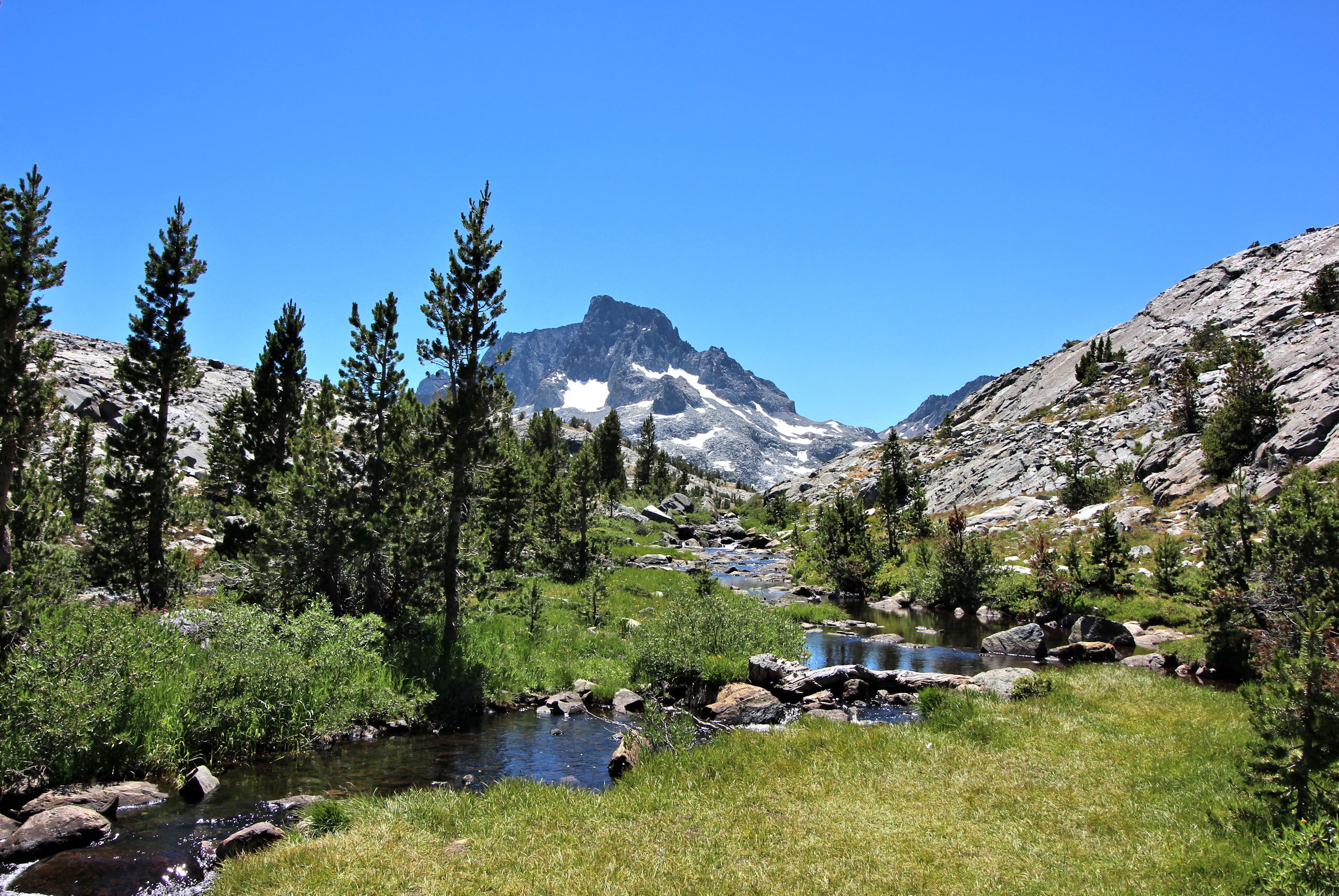
About six months prior, I spent many evenings and weekends studying topo maps, reading trip reports and forum discussions, and scrutinizing terrain on Google Earth, producing an 8 day itinerary starting from Agnew Meadows at Mammoth Lakes. But the real adventure starts on day 2 with a hike over the Ritter Range via North Glacier Pass and except for a small ¾ mile section later, remain off-trail for six days. My route would take me through Bench Canyon, Hutchings Creek Basin, and the Lyell Fork of the Merced River, areas that receive few visitors, and then return over Rodgers Pass and wind my way back to Mammoth Lakes via Davis and Nydiver Lakes.
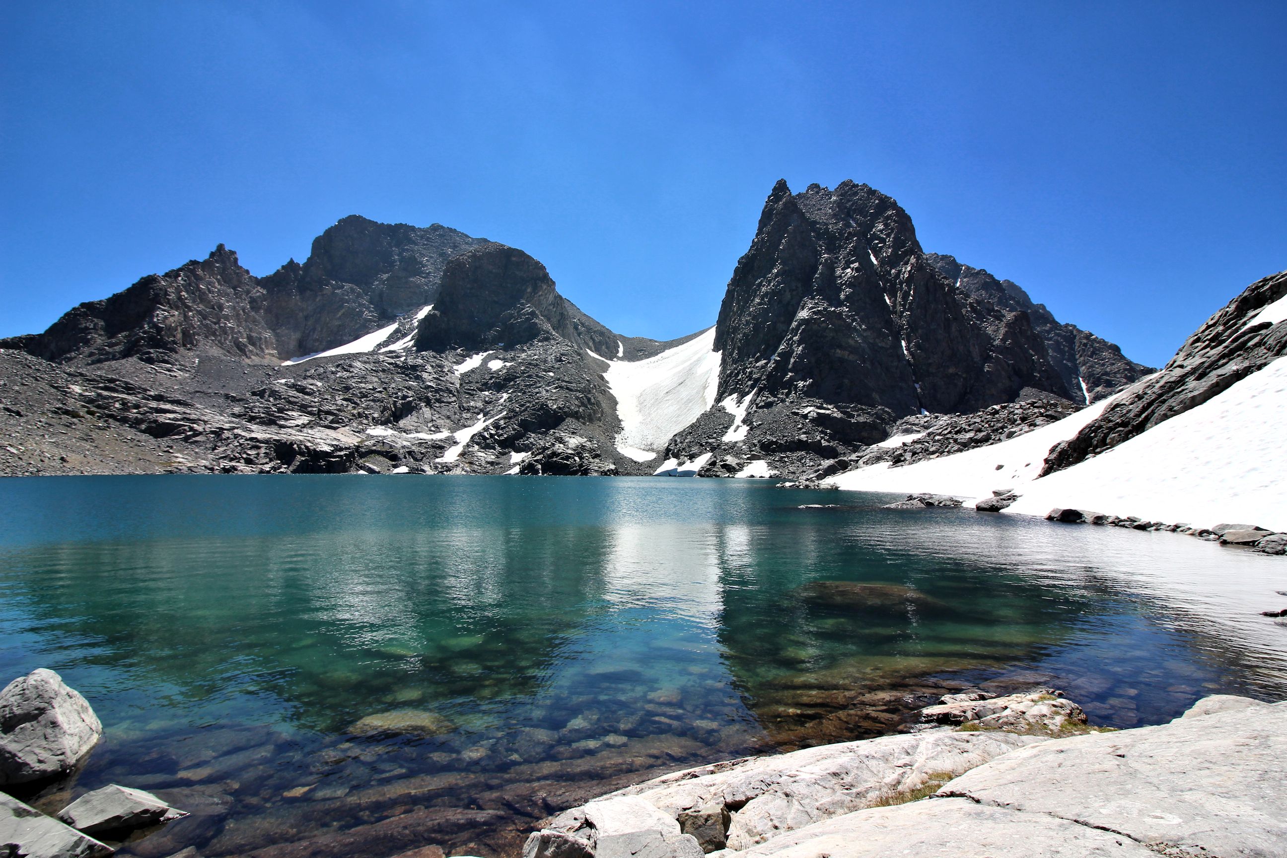
During my planning, I identified two sections that required extra caution. One was the west side of Rodgers Pass which is notorious for loose scree on its steep slope. The other was the descent from Lake Catherine down to Twin Island Lakes, where complex terrain and cliffs in the area force travelers to choose their routes carefully. This is actually a section of Roper’s Sierra High Route. But Roper’s book only provides a general description of the route to avoid spoiling the challenge many off-trail hikers seek. I had also penciled in an alternate route on my map that winds south towards Ritter Lakes before heading back north to the more commonly used route. According to my online research, this avoids some of the steep cliffs in the area.
On Day 2, from my private campsite west of Thousand Island Lakes, I reached the top of North Glacier Pass, picked my way along Lake Catherine’s rocky shore and past a small tarn, and was rewarded with my first view down the slope towards Twin Island Lakes. I was drawn down the beautiful landscape so decided not to take the alternate path. Using an assortment of easy granite ramps, I reached the top of a horseshoe cliff. With a river and waterfall to my left, my only choices were to climb down the cliff or continue along the high route to the right until I could find an easier descent. As I peered down the cliff, I saw a manageable route that went ¾ of the way straight down and then to the left around a corner. Unfortunately, the view around the corner was obstructed. Hopeful a path continued, I decided to climb down but discovered the path to the left was a long smooth granite slide that ended about 8 feet off the sloped ground. Perched at the top of the slide looking around, I think I had made the decision to go back up. I have no recollection of the next fifteen minutes of my life.
I didn’t know how much time had passed since I had activated my SPOT. Dialing 911 on my mobile phone repeatedly failed. But I was surprised to feel a little excitement about this ordeal, about breaking a bone for the first time, and the challenge to recover. I suppose I never seriously considered that I wouldn’t be eventually rescued. Still, I was relieved at hearing the helicopter blades and thought to myself that their response time was really quick. They flew overhead in the general area and each time they got close, I flashed my headlamp at them. This continued for maybe 20-30 minutes. My measure of time was not very accurate. The helicopter disappeared after a while before returning. Then it would disappear again. I thought they had seen me but could not find an area to land. Maybe they sent for a foot crew to come rescue me. The next time I saw the helicopter circle over me, I took out a shirt and started waving it. The helicopter sounded its horn in response. They finally saw me, and landed at 4:15pm, 4 hours after my fall.
The warmth of the sun on my face slowly stirred my consciousness. I opened my eyes, unsure if I was fading in or out of a dream. I laid comfortably on my back on a gentle incline of grass and rocks, soothed by the sound from a nearby waterfall. I soon realized that I was at the bottom of the cliff I was trying to climb down. A brief feeling of success quickly turned to concern of a possible injury. I stared at my swollen and crooked right wrist and wondered if that was the worst of it. Wiggling my toes in relief, I tried to move my legs next. My left leg did not respond. I tried again and noticed blood gush out from below my knee at each attempt. At that moment, I knew my hike was over and would need to call for help. I slowly got my backpack out from under me to retrieve my SPOT and activate its 911 feature for the first time.
In order to ensure my 911 signal wasn’t impeded by the cliff above me, I slowly dragged myself, my leg, and my backpack about 25 feet, creating a dotted line of blood as I shifted my leg every few inches. Finally satisfied with my location, I propped my leg on a rock, and settled in for the wait, with my bloody hat on my face for shade. I sat up a few times to take photos of the waterfall, my wrist and my leg. I even tied a bit of rope around my leg, hoping to slow the blood flow. But I was mainly relaxed and just waited.
About six months prior, I spent many evenings and weekends studying topo maps, reading trip reports and forum discussions, and scrutinizing terrain on Google Earth, producing an 8 day itinerary starting from Agnew Meadows at Mammoth Lakes. But the real adventure starts on day 2 with a hike over the Ritter Range via North Glacier Pass and except for a small ¾ mile section later, remain off-trail for six days. My route would take me through Bench Canyon, Hutchings Creek Basin, and the Lyell Fork of the Merced River, areas that receive few visitors, and then return over Rodgers Pass and wind my way back to Mammoth Lakes via Davis and Nydiver Lakes.
During my planning, I identified two sections that required extra caution. One was the west side of Rodgers Pass which is notorious for loose scree on its steep slope. The other was the descent from Lake Catherine down to Twin Island Lakes, where complex terrain and cliffs in the area force travelers to choose their routes carefully. This is actually a section of Roper’s Sierra High Route. But Roper’s book only provides a general description of the route to avoid spoiling the challenge many off-trail hikers seek. I had also penciled in an alternate route on my map that winds south towards Ritter Lakes before heading back north to the more commonly used route. According to my online research, this avoids some of the steep cliffs in the area.
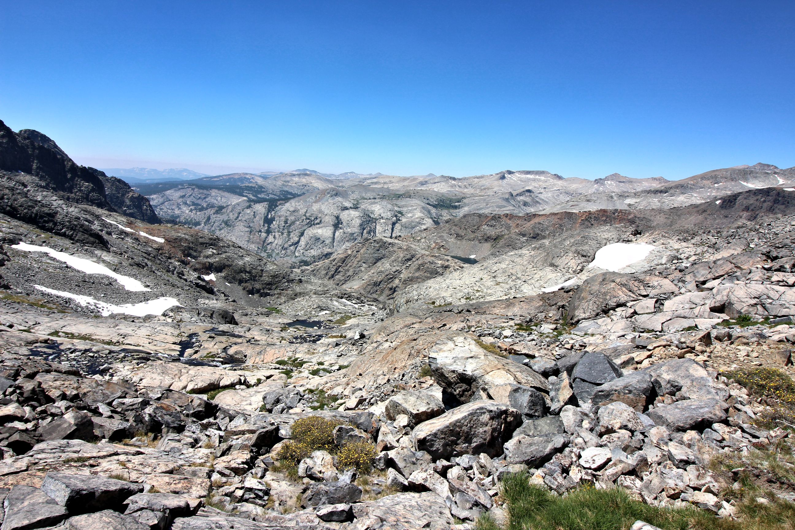
On Day 2, from my private campsite west of Thousand Island Lakes, I reached the top of North Glacier Pass, picked my way along Lake Catherine’s rocky shore and past a small tarn, and was rewarded with my first view down the slope towards Twin Island Lakes. I was drawn down the beautiful landscape so decided not to take the alternate path. Using an assortment of easy granite ramps, I reached the top of a horseshoe cliff. With a river and waterfall to my left, my only choices were to climb down the cliff or continue along the high route to the right until I could find an easier descent. As I peered down the cliff, I saw a manageable route that went ¾ of the way straight down and then to the left around a corner. Unfortunately, the view around the corner was obstructed. Hopeful a path continued, I decided to climb down but discovered the path to the left was a long smooth granite slide that ended about 8 feet off the sloped ground. Perched at the top of the slide looking around, I think I had made the decision to go back up. I have no recollection of the next fifteen minutes of my life.
I didn’t know how much time had passed since I had activated my SPOT. Dialing 911 on my mobile phone repeatedly failed. But I was surprised to feel a little excitement about this ordeal, about breaking a bone for the first time, and the challenge to recover. I suppose I never seriously considered that I wouldn’t be eventually rescued. Still, I was relieved at hearing the helicopter blades and thought to myself that their response time was really quick. They flew overhead in the general area and each time they got close, I flashed my headlamp at them. This continued for maybe 20-30 minutes. My measure of time was not very accurate. The helicopter disappeared after a while before returning. Then it would disappear again. I thought they had seen me but could not find an area to land. Maybe they sent for a foot crew to come rescue me. The next time I saw the helicopter circle over me, I took out a shirt and started waving it. The helicopter sounded its horn in response. They finally saw me, and landed at 4:15pm, 4 hours after my fall.