Hiking in a Storm on the PCT

If you've been searching for the best source of information and stimulating discussion related to Spring/Summer/Fall backpacking, hiking and camping in the Sierra Nevada...look no further!
User avatar
Hobbes
Topix Fanatic
Posts: 1120
Joined: Wed Apr 27, 2011 8:09 am
Experience: N/A
Location: The OC

Hiking in a Storm on the PCT

Post by Hobbes »

Had a fun four days hiking Section A of the PCT (109.5 miles from the US-Mexico border to Warner springs). Started 4/21 Tues morning and finished 4/24 Friday afternoon after continuously hiking 32 miles all day in order to get out. Here's a brief recap of the last day as a major storm moved into Calif:

From Scissors crossing (mile 77), the storm was strong enough that it was clearing the Laguna range and was making its way towards the San Felipe hills. The weather absolutely dictated a fleece/windshirt combo to stay warm even while hiking hard. There was an immediate climb out from 2,200 to 3,000 in the first mile just for starters. It was up/down and all around for the next 22 miles, including a drop down to 3,200 and then a final climb to 4,550. This is what the Half-mile map says:

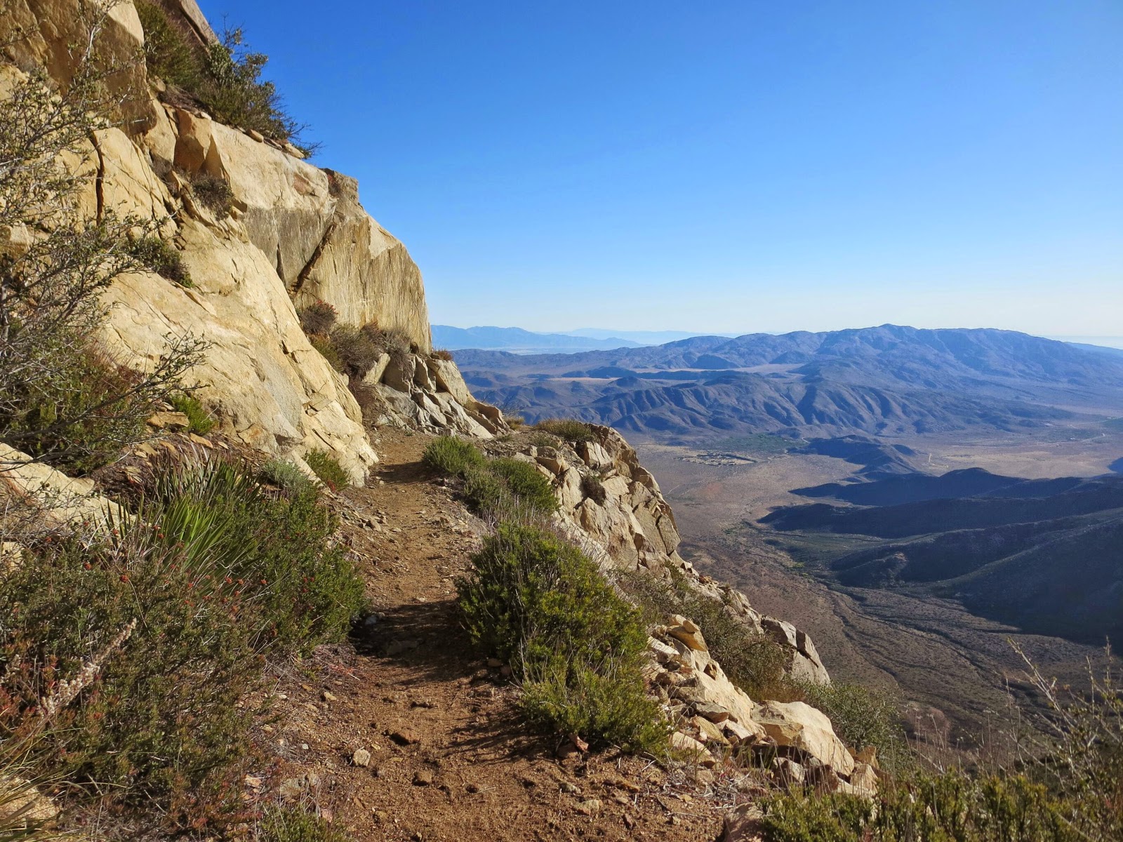
The San Felipe Hills [miles 78-100] are steep rocky hills with great views but limited camping. I have marked most of the available camping spots. Some campsites in this area are very small. Just large enough for a bivy or small 1 person tent.

And here is the view - really spectacular, but with a very high admission price:

Image

After leaving the Rodriquez spur tank @ marker 68.4 Thursday afternoon (the last water for 32.7 miles, requiring a 7 liter water carry), I had crossed the 2nd road under the bridge @ Scissors and made it to around marker 77.5: a 30 mile day from Mt Laguna @ 47.5. It was right before 8pm in the dark, so I finally threw down my stuff and crashed cowboy style in the wind blown sand just off trail. I have to confess I felt like some lonely, forlorn hobo as the cold desert wind kept ruffling/lifting my quilt all night long, along with gusts threatening to blow away some of my gear off into the wasteland. I think I might have gotten a few hours of sleep, if that.

I got going the next morning @ 6:15am and hiked very fast for 3 hrs to marker 86.6 - 9.1 miles or 3.3mph - I was in a hurry. The wind was very cold/strong on each north turn of the trail, but I noted it was (sort of) ok in the (tiny) southern lees. As I was hiking along, I was making mental preparations on how to pull off an emergency bivy if the situation really deteriorated, so I was calm & ready in my head on what to do in terms of how to lay out my tarp, which direction, protect my down, etc, if it came to it.

Finally, the trail dropped down to 3,200' at a wide sandy wash @ 86.6 with a perfect SE nook, so I decided to sit, wait and see what the weather was doing. I stayed there for 1.5 hrs till 10:45, and figured even if the storm arrived full force, I could top the ridge by 1pm - that is, the (relatively) warmest part of the day. I knew it was another hard 8.9 miles until the ridge topped out @ 4,550' at marker 95.5, so off I went hiking as fast as I could - head down, don't look at the views, watch your feet/trail, and monitor the time. The result? I think I must have set some kind of personal record for a steep/long hill climb: 3.5mph.

It was like hurricane force winds up there - on every turn of the trail spur to the west, I was constantly hoping/praying that the end was near. But I kept seeing the trail climb higher yet as the skies became progressively darker and the peaks were enveloped in clouds. In a situation like that, you could really lose heart/confidence if you didn't have faith in your capabilities & a good idea of where you were. Hence the training, studying the route/maps and preparing detailed mileage plans with specific waypoints. (I had hardcopies with me that I reviewed while hanging at the wash.) However, I was periodically peeking at my watch and knew the ridge point had to be nearing (ie I knew both the distance and my pace from my start @ the wash). Finally, the trail took a turn to the east and started going down the other lee side of the range to a dryer area to the east. I had made it - talk about relief. I continued the long walk down to Barrel springs elated I was getting off that mountain. It was another 5.6 miles, and I cranked up the pace again to 3.6mph.

I got into Barrel springs (mile 101.1) around 3:20 and hung out talking to some trail angels. I ate my refried beans and chilled as some other hikers got ready to head to Warner springs. They had only hiked down from 3rd gate, so it wasn't a big deal. After already hiking almost 24 miles over very rough terrain, I was pooped, so I certainly didn't have the energy to tackle any more grades. However, one of the angels assured me it was just a continuation of the rolling hills and (BLM) grazing pasture I could see from the spring, so I popped a Motrin and decided to go for the additional 8.4 miles @ 3:50.

Now, by hiking fast and wearing my fleece/windshirt combo, I had managed to both stay warm & beat the storm on the high ridge, and luckily avoided a potential wet-out and hypothermia situation. Not so for the hike to Warner springs - the storm finally moved in, but I knew it if I hiked really, really fast, I could get there just after 6pm (@ almost a 4mph pace). Since technically it was still daylight, and I had my car and warm clothes ready for me, after what I had just been through I knew even if I got thoroughly soaked and cold, I could physically & mentally handle "only" another 2+ hrs.

So off I went into the most surreal hiking experience of my life. It was way crazier than the snow storm on Whitney in terms of visibility (but of course not anywhere close to actually being dangerous) and eerily empty. I could only see clearly for maybe 50 yards, and max maybe 300-400 yards as the wind whipped the rain sideways. The trail just went off into the whiteout across the pasture lands. Every now and then there would be some low knolls, but after what I had been through as far as grades, it was a joke. I was becoming absolutely soaked even with my poncho, so I just kept my head down and charged. Every now and then I'd take a quick peek at my watch, so mentally I knew it was just another hour, another 15 minutes, another ... wait, I could hear the CDF radio crackling @ the road. I made it @ 6:05, for a new official record of 3.75 mph sustained over 8.4 miles. The grand total was 32 miles in 9.1 hours, or 3.5mph. That's what desperation can do for you - yipes.

Without doing anything else, I immediately found my key, started the car and turned the heat on full blast. I then went about changing out of my soaking wet clothes/shoes, put on my dry stuff (I always keep a change of clothes in my car), jumped into the car, did some quick texts to my wife/family/friends saying I was safe & ok, and took off for home.

Some other hikers posted short video clips that captured the situation during the Friday storm. Photos are better than 1k words, etc - click links for video:

Image

https://instagram.com/p/16no1yIkbS/

Image

https://instagram.com/p/16nzYbokbg/
User avatar
Wandering Daisy
Topix Docent
Posts: 6689
Joined: Sun Jan 24, 2010 8:19 pm
Experience: N/A
Location: Fair Oaks CA (Sacramento area)
Contact:

Re: Hiking in a Storm on the PCT

Post by Wandering Daisy »

Were you part of the big official starting group? Being chased by a storm and hiking in thick fog sounds scary! As well as the wind. Glad you made it out OK.
User avatar
Hobbes
Topix Fanatic
Posts: 1120
Joined: Wed Apr 27, 2011 8:09 am
Experience: N/A
Location: The OC

Re: Hiking in a Storm on the PCT

Post by Hobbes »

Wandering Daisy wrote:Were you part of the big official starting group? Being chased by a storm and hiking in thick fog sounds scary! As well as the wind. Glad you made it out OK.
No, it was just Jim and myself starting @ 8am from the border after dropping our cars @ Warner springs.

Image

This group got started @ 6:30am - we passed them all long before we reached Hauser creek @ mile 15. We continued to Boulder oaks @ mile 26 (thereby missing the annual kick-off scene @ lake Moreno at marker 20), so we never saw any of them again:

Image

I don't want to downplay the storm too much, but the temperature never dropped below freezing in the San Felipes. Sure, technically the wind-chill equivalent might have been sub-32, but it wasn't going to snow. Now, the day before (Thurs) - when Jim & I came down from Mt Laguna to Scissors - might have actually been a little more scary. The storm was just developing, but what made it more dangerous is that the Laguna range drops off like the eastern Sierra escarpment. The PCT runs along the vertical ledge & follows every contour, and wind gusts were easily over 50mph. It's why we (and another 10 or so hikers) cut the day short @ 22 miles on Wed in order to hit the Laguna campground @ marker 47.5 (+.5 to get there). Still, we had to get off the mountain on Thurs, and the trail continued to follow the upper ridgeline for another 10 miles before finally dropping down to Chariot canyon (and then back up! to Rodriguez for the last water location):

Image

Here's another person's dramatic account of her experience just to get to the campground:

Though I had planned to take a zero (or day off) in Mt. Laguna due to the giant wind storm heading in that day, after speaking with the clerk at the outfitters store that morning, who assured the next 4.5 miles to Laguna Campground were safe to make (but none after that due to the highly exposed ridge), I decided to move on.

https://trailtraveler.wordpress.com/201 ... hey-raged/
User avatar
Hobbes
Topix Fanatic
Posts: 1120
Joined: Wed Apr 27, 2011 8:09 am
Experience: N/A
Location: The OC

Re: Hiking in a Storm on the PCT

Post by Hobbes »

A couple more reports are starting to trickle in from the Friday storm; here are two more:

As I write this, I’m laying in my sleeping bag in an empty water tank off a dirt road, which was BEST case scenario for what was an increasingly dire situation. Now let me tell you how we got here.

https://chasingmydaydream.wordpress.com ... the-storm/

Well, today was a bit of a character-building day. I woke up around 4 this morning with some anxiety about the day's hike. I had pretty much committed to skipping the hitch hike in to Julian where I could refill water and take advantage of the rumored free pie. This meant that if I didn't want to rely on water caches, I had to make it all the way to Barrel Spring on the 5 liters I had left from the Rodriguez Spur tank. I've been using much less water than I anticipated, and I figured that with the cool weather I should be able to make that push OK. But the big unknown was how my body, and especially my knee, would handle all those miles, potentially all in one day.

http://sfjonthepct.blogspot.com/2015/04 ... day-7.html

---

By the way, you will see mention of how poorly some UL tents/tarps fared in the storm. My own personal opinion is that if I were to ever actually attempt to do the entire trail, I would definitely spend the $ on a free-standing tent like the Fly creek platinum and buck-up carrying the extra weight. Unlike shorter trips in the Sierra, where you have the option of delaying, cancelling, or modifying your plans (including bailing out), once you're committed to thru-hiking the PCT, it's your place of residence. That means you need a "real" abode (including a vestibule which acts as a front porch) in which to hang-out on the trail. It's also imperative that it be both quick & easy to erect, and wasn't dependent on guy lines/stakes to maintain shape (though they are nice complements in really poor weather). This is sort of a major epiphany for me, one who takes a simple DIY tarp and never puts it up.
User avatar
freestone
Topix Expert
Posts: 963
Joined: Fri Nov 11, 2005 9:42 pm
Experience: Level 3 Backpacker
Location: Santa Barbara
Contact:

Re: Hiking in a Storm on the PCT

Post by freestone »

How was it hiking in sandals?
Short cuts make long delays. JRR Tolkien
User avatar
Jimr
Forums Moderator
Forums Moderator
Posts: 2176
Joined: Fri Jul 31, 2009 2:14 pm
Experience: Level 4 Explorer
Location: Torrance

Re: Hiking in a Storm on the PCT

Post by Jimr »

Personally, I loved hiking in sandals, but (and that's a big but) the heels get dry quickly and risk cracking. The Injiji toe socks were a welcome addition and eliminated that issue altogether. Now for the big BUT! At around mile 11, my left knee started complaining and got worse with every mile. I did around 25 or 26 the first day, chasing down the sun. I hit camp at the start of the blue hour and my knee was killing me. Every evening, I'd down a few vitamin i and a shot or two of whiskey. Morning was assessment time; hike or bail. I chose hike every morning and suffered through another 20+ miles on an agonizingly painful knee, adjusting my gate and speed to minimize the pain, take a 1 minute break every hour and a 30 minute lunch.

By the time I hit Rodriguez spur, I was in agony. Hobbes suggested I camp there and split the last 40 miles up knowing I had an extra day if needed. I was on plan and we agreed to split up and he would go for broke and I would stay the course. Well, I had to follow what my body was telling me. I rested up a bit at RS, filled 7 liters of water, took some Motrin and a shot, then a dump. I was impressed that I could squat without pain. For the last two days, I couldn't even lift my heel half way to my ass without severe pain. I hiked on for about 7 more miles; just about a half mile from the desert floor, then bivy'd up with another hiker for the night. He was slightly hesitant when I asked if he would share his spot with me because it had excellent wind protection and it was almost dark, but agreed and was happy to do so once he made his decision. He moved his ground tarp over and I cozied in next to him. It was an excellent decision for him. He had been battling a cold and couldn't breathe. I gave him all of my cold and sinus medicine and we shared company until bedtime. The wind was wild but we were fairly protected.

I packed up early the next morning and headed off knowing I had 3 days to get another 35 miles or so. As I headed toward the desert, my right calf got pissed at my left knee for having to take on the extra work that my slacker left knee refused to do. I hobbled through the desert toward Scissor Crossing pondering my situation. When I hit the road crossing, I noticed a road sign at the T intersection and decided I would check it out. The San Felipe hills were shrouded in storm clouds and the trail going straight up and into the storm did not look inviting, especially in my condition. I decided I would head to the crossing and hitch out. As soon as I hit the trail crossing, an SUV pulled up and stopped right in front of me. I told them of my situation and that I needed to find a ride to Warner Springs and get off the trail. They said they were dropping off one of their party right there to resume, then they were heading into WS and there was a seat just for me. Within a half hour, I was back at my truck and heading home.

Reflecting upon my situation and the fact that I've never experience this type of injury before except on the last day hike where I used sandals, I suspect that although the sandals were wonderful on my feet, it may put too much of a burden on my knees. Downhill is hard enough on the knees, which we have all experienced, but with sandals (for me, at least), there seems to be extra strain put on the knee joint. I've decided that the sandals will replace my running shoes as camp shoes and maybe some hiking, but only after some miles on trail when the body is dialed into the hiking regimen.

I had thrown out to Hobbes, sort of tongue in cheek that we learn the mind controls the body and this hike will put that theory to the test. Be careful what you put out into the universe, you may just receive it. Normally, my mind hikes along to a song with a cadence that matches my desired speed and my gait keep time. It was interesting that the two songs I played in my head daily were; on the up hill slopes "Keep pushin' on" by REO Speedwagon. On the flats and downhill, "Horse with No Name" by America". Fitting tunes I think. :rock:
If you don't know where you're going, then any path will get you there.
User avatar
Hobbes
Topix Fanatic
Posts: 1120
Joined: Wed Apr 27, 2011 8:09 am
Experience: N/A
Location: The OC

Re: Hiking in a Storm on the PCT

Post by Hobbes »

It was a great relief to see Jim's truck gone from the parking lot @ Warner springs when I finally arrived. As I was hiking through the storm, I intuitively knew he would have made the right decision; that was no place to be unless you were 100%. So I smiled when I saw his text wondering where I was - he was already home while I was changing out my soaked clothes with a long drive still ahead. :crybaby:

When Jim rolled up @ Rodriguez spur, I was pretty adamant about him not pursuing a course of action that could result in actual injury. That would convert what was ostensibly a 'training hike' into one that could have sidelined him for a year or more. So, I advocated for him to stay @ Rodriquez, rest up and make an assessment the next morning.

[As an aside, the sandals I had considered bringing could have been a disaster (Jim's Tevas are much sturdier). I am so, so glad I brought just my Altras. The initial 26 miles from the border is standard trail, but the next 16 miles up to Mt Laguna are as rough as I've experienced. Very, very rocky, gullied out and nowhere to actually gain a stride, resulting in a slow day. The total gain was only 2700' - on par with Silver lake to Agnew pass - but for some reason I felt worked.]

I, on the other hand, wanted to try for four days, which meant I needed to continue on to Scissors (to finish with a 30 mile day) in order to be in position to pull off a 32 the next day (Friday) to get out. I gave Jim a fist punch and left RS around 5pm, and experienced this beautiful scene while dropping down to the desert floor:

Image

Later, knowing his condition, I was surprised that Jim had made the decision to continue on down to Scissors later that day as well. But, he certainly made the right call to bail on Friday. I was almost despondent looking up at the climb out into the San Felipes from Scissors crossing - it literally looked like a hiking trail version of the Horseshoe meadows road laddering up the escarpment.

For anyone who is interested in trying section A, I would give it a AAA+ rating. I can see now why it is compared favorably to the Sierra & N Cascades as everyone's favorite section. Huge views, beautiful scenery, and oddly enough, super empty; much, much less traffic than a typical summer day in the Sierra. The reason is, of course, that no one is going southbound at this early stage, there aren't many exit/entry spurs for day hikers or overnighters, and ... you're in a bubble. That is, there could 50 people ahead of you and 50 people behind, but unless you're slower/faster, you'll never see them. And that's during kick-off; leave a week earlier or later, and you can find real solitude.
User avatar
Jimr
Forums Moderator
Forums Moderator
Posts: 2176
Joined: Fri Jul 31, 2009 2:14 pm
Experience: Level 4 Explorer
Location: Torrance

Re: Hiking in a Storm on the PCT

Post by Jimr »

"it literally looked like a hiking trail version of the Horseshoe meadows road laddering up the escarpment."

That is exactly what I thought. I knew every day that I had the means and opportunity to bail out, but as I hit Scissors Crossing, I knew that if I passed that road, I was committing to the next 32 miles alone and unable to bail if need be. That zig zag trail into the mist was no place I wanted to be hobbling around on.
If you don't know where you're going, then any path will get you there.
User avatar
schmalz
Topix Expert
Posts: 588
Joined: Fri May 07, 2010 9:18 am
Experience: Level 4 Explorer
Location: Altadena, CA
Contact:

Re: Hiking in a Storm on the PCT

Post by schmalz »

Hobbes wrote:
For anyone who is interested in trying section A, I would give it a AAA+ rating. I can see now why it is compared favorably to the Sierra & N Cascades as everyone's favorite section. Huge views, beautiful scenery, and oddly enough, super empty; much, much less traffic than a typical summer day in the Sierra. The reason is, of course, that no one is going southbound at this early stage, there aren't many exit/entry spurs for day hikers or overnighters, and ... you're in a bubble. That is, there could 50 people ahead of you and 50 people behind, but unless you're slower/faster, you'll never see them. And that's during kick-off; leave a week earlier or later, and you can find real solitude.
Sounds great. Does that section enter Anza Borrego or any other state parks? (aka is it dog friendly?) I haven't spent enough time investigating that.
http://CaliTrails.com" onclick="window.open(this.href);return false;
http://facebook.com/calitrails" onclick="window.open(this.href);return false;
User avatar
maverick
Forums Moderator
Forums Moderator
Posts: 11834
Joined: Thu Apr 06, 2006 5:54 pm
Experience: Level 4 Explorer

Re: Hiking in a Storm on the PCT

Post by maverick »

Sounds like a fun trip, wish I could have attended. Like the new hat Jim. :)
Professional Sierra Landscape Photographer

I don't give out specific route information, my belief is that it takes away from the whole adventure spirit of a trip, if you need every inch planned out, you'll have to get that from someone else.

Have a safer backcountry experience by using the HST ReConn Form 2.0, named after Larry Conn, a HST member: http://reconn.org
Post Reply

Who is online

Users browsing this forum: No registered users and 58 guests