TR: Southern JMT on the brink of winter, October 2018

If you've been searching for the best source of information and stimulating discussion related to Spring/Summer/Fall backpacking, hiking and camping in the Sierra Nevada...look no further!
User avatar
kharring
Topix Novice
Posts: 8
Joined: Mon Apr 15, 2019 3:19 pm
Experience: Level 4 Explorer

TR: Southern JMT on the brink of winter, October 2018

Post by kharring »

In October 2018, two good friends and I adventured into the backcountry of Sequoia and Kings Canyon National Parks. It was 5-day backpacking trip on the eve of a Sierra winter. The plan was to track the last 40 miles of the John Muir trail. The extreme cold we encountered turned a well-planned trip upside down.

I hauled in my A7RII with a couple of lenses and made it a priority to photograph the adventure so I could put together a trip report. Here's my favorite photo from the trip, the Kearsarge Pinnacles of Kings Canyon National Park:
Image
User avatar
c9h13no3
Topix Fanatic
Posts: 1326
Joined: Tue Sep 18, 2018 1:19 pm
Experience: Level 1 Hiker
Location: San Mateo, CA

Re: TR: Southern JMT on the brink of winter, October 2018

Post by c9h13no3 »

What a tease of a first post.

Moar pics :drool:
"Adventure is just bad planning." - Roald Amundsen
Also, I have a blog no one reads. Please do not click here.
User avatar
kharring
Topix Novice
Posts: 8
Joined: Mon Apr 15, 2019 3:19 pm
Experience: Level 4 Explorer

Re: TR: Southern JMT on the brink of winter, October 2018

Post by kharring »

We wanted to hike a total of 30 to 40 miles in 5 days and we wanted to see the backcountry of SEKI, specifically the majestic alpine zone around the treeline. We needed to start and end from the east side of the Sierra where the roads get within miles of the summit for quick access to the alpine zone even though we live on the west side of the Sierra. This narrowed our trailheads down to four: Onion Valley, Shepards Pass, Whitney Portal, and Horseshoe Meadows.

Of those trailheads, Onion Valley is by far the shortest distance to the SEKI backcountry at only four miles on foot. I didn't want an out and back hike, so I tried to put together a loop that connected trails starting and ending in Onion Valley. Here's what I proposed:
Image

But my loop got vetoed because Alex pointed out that one of the trails goes over Harrison Pass. Which, as others have reported on here, is really really gnarly and a dangerous "trail".

The trail density of the region is so low that it's nearly impossible to create a loop of trails without hiking less than ~75 miles or going off trail. We ended up settling for a route that started in Onion Valley and ended in Lone Pine Creek Canyon (Whitney Portal). It followed the summit of the Sierra via the John Muir Trail. Here's the route in Google Earth:

Image
User avatar
kharring
Topix Novice
Posts: 8
Joined: Mon Apr 15, 2019 3:19 pm
Experience: Level 4 Explorer

Re: TR: Southern JMT on the brink of winter, October 2018

Post by kharring »

We meticulously packed for this trip. It wasn't our normal Sierra backpacking trip where great summer weather allows for mistakes in packing. As you know if can be cold in mid-October in the high Sierra. The right amount of food, fuel, and clothing are necessary for a safe trip this time of year.

Here's my spreadsheet I used to determine what to bring. I weighed ever item with a mail scale. My pack weight plus the weight of stuff I wore was 54 lbs for this trip.
Image

Usually, I'm in the 30 lbs range, but on this trip, we had to bring:
- Extra food to account for the expected freezing weather.
- Extra warm gear, for me that included two down jackets and an extra sleeping bag.
- A tent with rainfly. Often I'll just bring a tarp to sleep on in sunny summer weather.

I figured I'd burn 200 calories per mile on the 43 miles of backpacking with a 50lbs on my back going over steep terrain at average elevations above 11k feet, plus about 3000 calories a day for 5 days for keeping warm in the wind and cold. 23,600 calories food supply was my target.

I have a chart of extremely high calorie to weight foods:
Image

And from that chart, I made a list of foods to bring.
Image

I ate all those calories on the trip, and still came back 5 lbs lighter.
User avatar
kharring
Topix Novice
Posts: 8
Joined: Mon Apr 15, 2019 3:19 pm
Experience: Level 4 Explorer

Re: TR: Southern JMT on the brink of winter, October 2018

Post by kharring »

Day 1

A thru-hike is logistically complicated. Luckily, we had two cars on our trip, so we placed a car at both the starting and ending trailhead. It took a few hours to place the getaway car at Whitney Portal then drive to Onion Valley for our departure on the trail. This time of year the days are only light for about 12 hours, and in the alpine zone, mountain shadows linger for hours after sunrise and before sunset.

We started our journey on foot at 2 pm, much later than intended. We only had 5 hours of light left. Our goal was to hike 10.6 miles to a camp in upper Kings Canyon. The first 3.8 miles were all uphill, rising nearly 3000 ft to the first major foot pass of our journey, Kearsarge pass at 11,800'.

It was warm, 50 degrees, there was no wind. We had all our layers off to avoid sweating.
Image

We were excited:
Image

Fall colors were in full peak at 10,000ft. Soon we'd be in those clouds above.
Image

Sure enough, the weather got spooky in the clouds at 11,000ft on Kearsarge Pass.
Image

We lost the sun behind the mountains around 5:30pm. And it was so so cold. A steady breeze chilled our bones. We layered up with insulated jackets and shells to break the wind.
Image

Alex was tired. We all were. Having been a sea level for weeks before, the elevation beat us. It was a slow slog to the top of the pass.
Image

We crested Kearsarge Pass at 6:30 pm. It was pitch black. We were hiking with headlamps at this point. I convinced Alex and Kevin we needed to freeze our butts off to photograph the Kearsarge Pinnacles. I propped my camera on a rock and pointed it into the black abyss. A 30 seconds exposure at ISO 320, f/1.8 21mm produced this:
Image

I was stoked, but shivering. We hiked into the night for an hour. And stopped 5 miles short of our planned camping spot.
Image
We didn't get as far as we wanted to 😢
User avatar
kharring
Topix Novice
Posts: 8
Joined: Mon Apr 15, 2019 3:19 pm
Experience: Level 4 Explorer

Re: TR: Southern JMT on the brink of winter, October 2018

Post by kharring »

Day 2

We woke up to a sunny but chilly morning with 20 mph winds. The view of Kearsarge lake from our camping sport was incredible.

We got on the trail at 11 am, undesirably late. But we were so cold in the morning, it was hard to get out of our sleeping bags until direct sunlight hit camp at 9 am. Photo by Alex. I'm not a morning person and didn't want to wake up to get this epic photo.
Image

Here's Bullfrog Lake.
Image

We dropped down into the upper south fork Kings Canyon, about 15 miles upstream of the nearest road in the park. It was epic. This massive canyon bigger than Yosemite Valley had merely one trail running through it. This was desolation.
Image

We were still so beat by the elevation since we just came from sea level.
Image

The goal for Day 2 was to catch up on miles by making it over the Forester pass, but a storm was rolling in and daylight was quickly running out. Forester Pass sits in the storm clouds of the photo below.
Image

Forester Pass stands at 13,200 ft, far above the tree line. A storm at this altitude could be deadly, especially with negative nightly temperatures.
Image

We decided to wait out the storm. We setup camp a few miles from the top of the pass and hoped the clouds would break in the morning. Here's the view down Kings Canyon from camp.
Image

It was a cold night. Here's looking up at Forester.
Image

We got a light dusting of snow.
Image
User avatar
kharring
Topix Novice
Posts: 8
Joined: Mon Apr 15, 2019 3:19 pm
Experience: Level 4 Explorer

Re: TR: Southern JMT on the brink of winter, October 2018

Post by kharring »

Day 3

The weather was better the next morning. The storm broke around 9 am. @xelanil's view from his tent:
Image

Alex's thermometer read a hair less than 30F. A cold front was rolling in.
Image

We were only 11.7 miles in. And we had 3 more days to finish the 43 mile journey. We had 72% the distance left even though we spent about 60% of our time already. The remaining trail had two major obstacles, Forester and Trail Crest Passes, both dwarf Kearsarge Pass at over 13,000 ft.
Image

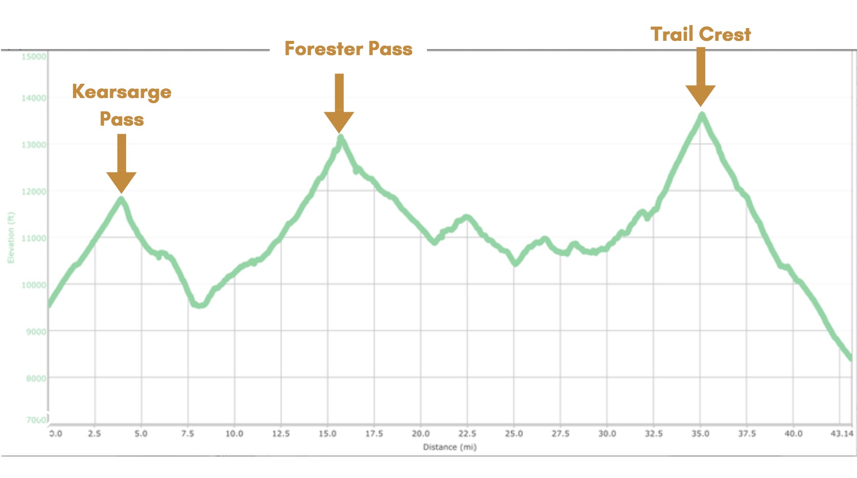
We had to make up some serious miles on Day 3 if we were going to complete the journey on time. We got an earlier start on the trail. The first half of the day was spent climbing Forester pass. We had to constantly stop to add and remove layers to regulate our body temperatures. We didn't want to sweat in freezing temperatures to fear of the sweat freezing to our bodies.
Image

We were stoked we were making good progress.
Image
Image
Image

The landscape looked like the Himalayas.
Image

We made it to the top of Forester Pass around 2 pm.
Image

The crossing from Kings Canyon to Sequoia National Park was epic. The trail did not disappoint. It was etched out of a 1000ft cliff.
Image
Image
Image

We cruised through the first valley of Sequoia National Park. It was absolutely beautiful.
Image
Image
Image

But so so cold, even on a sunny day. Icicles had formed between rocks, and not even direct sunlight at 12,000ft could melt them.
Image

We made it to an ancient forest at near sunset. I'd never seen anything like it. These were huge 2000-year-old trees thriving at 11,000 ft where the air is thin and most trees can't grow.
Image

That day we made it to the 20.0 miles mark. That meant we had 23 miles left in the last 2 of 5 days. Days were too cold and too short to get more than a few hours of hiking in. Our packs were heavy. And we were not acclimatized properly. It was clear we couldn't finish the journey on time without killing ourselves.

We had enough food to draw out our trip, but we told our loved ones back at home to call the ranger station if we didn't report back to them by 11 pm on Day 5.

There is a pass that exits to a trailhead halfway between Whitney Portal and Onion Valley called Shepherd Pass. It was 14.5 miles from our camp to the trailhead of Shepherd pass. It was much closer than any other trailhead, and only have 2000 ft of climbing as opposed to 5000 ft of climbing if we turned around or continued to the Whitney portal.

The Shepherd pass had three downsides. First, we would have to arrange a ride to one of our cars from the Shepherd pass trailhead. Second, the map said "Stock not recommended" which meant it could be really steep and dangerous. And third, it was 7000 ft of vertical descent. This is an extreme amount that would put a lot of stress on our joints.

Our group of three made the unanimous vote to exit Shepherd Pass the next day.
Image
User avatar
kharring
Topix Novice
Posts: 8
Joined: Mon Apr 15, 2019 3:19 pm
Experience: Level 4 Explorer

Re: TR: Southern JMT on the brink of winter, October 2018

Post by kharring »

Day 4

That morning I filled my camelback with water from a flowing river nearby, added my Aquamira treatment drops, then waited the specified 20 minutes before drinking. To my surprise, the 2 liters of water was nearly frozen solid. This cemented our decision to exit Shepherd pass.
Image

Despite the fact that our camp was fairly low compared to the average altitudes we were at hiking at, it was extremely cold that night. At 8 am, our thermometers read 5F. That's at 10,500 ft, our lowest campsite, in the sun. That meant the temp could have been below 0F before dawn. The coldest I've slept in the Sierra, even colder than winter ski and snow camping I've done.
Image

We all froze that night. Our sleeping bags weren't rated for those temperatures. I saved a NOAA weather forecast to my phone for that elevation on the day we departed on our journey. I pulled out my phone and reconciled our recorded temperature and the forecasted temp: "Clear, with a low around 29"

The forecast was dangerously inaccurate. We were equipped for such temperatures, but another night at that elevation would be torture. And we had no guarantee that the temp would not drop even more. We eagerly embarked on our exit from the Sierra high country.
Image

It was absolutely beautiful that morning. The storm days before and the cold front that followed cleared out all the smog and dust. The sky was a perfect blue.
Image

Our fears of Shepherd pass were realized when we dropped into a chute that consisted of a loose talus field. Snow on the trail made navigating the steep terrain quite dangerous. By my estimates, the terrain was YDS Class 3 at the top because the trail was unusable because of snow or just wiped out. We had to be extremely careful.
Image
Image
Image

To our surprise, the chute was littered with elk? body parts. Maybe 50 elk died in this chute.
Image
Image
Image

My theory was an avalanche took out a heard in the winter before, and the snow had finished melting this September-October. Fresh coyote poop filled the trail. Coyotes must have ravaged the recently unfrozen dead Elk bodies.

It was a relief to finish the steep terrain. We spend the next five hours descending the remaining 6000 ft via hundreds of switchbacks. Although we had another day left, there was not a single suitable area to camp in the remaining 10 miles. The trail was 1 foot wide at most and on a 60-degree mountainside the whole way down.
Image

We made it to the 6000ft trailhead around 8 pm. We were 45 minutes by car from our closet vehicle in Onion Valley. The last few miles to the trailhead was a 4x4 road. Getting a ride was impossible at this hour where no taxi service operates.

We had 5 days of food and fuel, so camping at the trailhead on Day 4 was comfortable, especially because the trailhead was much warmer than our last camp, about 4500ft higher in altitude.
Image
User avatar
kharring
Topix Novice
Posts: 8
Joined: Mon Apr 15, 2019 3:19 pm
Experience: Level 4 Explorer

Re: TR: Southern JMT on the brink of winter, October 2018

Post by kharring »

Day 5

We found a guy listed on the US forest service website that provides hiker transportation. $70 got us a ride from Shepherd pass trailhead to Onion Valley. From there we collected the other car at Whitney Portal.
Image

It was a remarkable trip. We went 48 hours without a single another person, and we saw 5 other people on our whole journey. We found solitude.
Image

I could barely walk. My calves and quads were aching. The switchbacks the day before were killer. Here's our actual GPS tracks:
Image
User avatar
davidsheridan
Topix Regular
Posts: 221
Joined: Thu Jul 10, 2014 2:56 pm
Experience: Level 3 Backpacker

Re: TR: Southern JMT on the brink of winter, October 2018

Post by davidsheridan »

Thanks for sharing your trip report, sounds like an adventure, and also a learning experience. By posting here, you're helping other people learn from your experience as well. I think the fact that you guys were flexible and changing your plans, and not Dead set on your initial itinerary, was really important in keeping you guys safe. After all that, it sounds like it was a fun adventure.
Post Reply

Who is online

Users browsing this forum: Google Adsense [Bot], John Harper and 226 guests