Hello. Here is an artmap of the Mokelumne River Canyon. I made this for Chip Morrill, the Forest Service Ranger in charge of trails inside the Mokelumne Wilderness Area.
Backstory: Last Spring I did a backpack trip up the river canyon, cross-country, from Salts Springs Reservoir. The flow was in spate. I believe "brawling river" is the correct way to describe the thing. I found lots of ants and poison oak, but also plenty of Yosemite-like scenery, too. To exit the canyon, I used the trail connecting Camp Irene with Munson Meadow.
WARNING: This trail is (17E27.3) is currently impassible. From Camp Irene to the junction with the spur leading to Munson Meadow the tread is faint and yet it's still passible. However, from 5600 feet up to about 7000 feet the brush is horrendous. It's an Alder Swim. We are talking about 100 yards per hour, of non-stop hand-to-hand combat. I managed to burrow my way through, but not on my first attempt.
Anyhow, the Eldorado Forest is run on a tight budget; they rely on volunteers to help with trailwork. I doubt I can get out there myself, but I wanted to help somehow, and so I whipped up this artmap and gave it to Ranger Chip, with the hope that it might be useful in a volunteer recruiting poster. I'm not sure if he ever used it or not. I donated it to the Forest Service, without any strings attached, so it's not a big deal if he didn't use it.
While leafing through Backpacker magazine, I saw an ad for a non-profit group called "Wilderness Volunteers." Forthwith a copy of my Artmap was sent to Aidalicia, the group's Project Manager. She thanked me, and expressed interest in the area.
Recently I checked their website, and found they have a service trip planned in the canyon.
www.wildernessvolunteers.org/project/20 ... orest.html
This will happen in early August (assuming we are all healthy and hardy, of course). From what I can glean from the website, it sounds as if their chief area of focus is the Summit City Canyon corridor (the old Tahoe-Yosemite Trail). I hope they might have a day or two to do some work on the spur up to Munson, as well. Of the two routes, the Munson route needs maintenance more badly.
So, I'm posting this artmap to show off my drawing skills, and to drum up some benevolent interest in the region.
Sincerely,
Carl Raillard
Mokelumne Wilderness Artmap - trailwork challenge
-
CarlRaillard

- Topix Acquainted
- Posts: 29
- Joined: Wed Apr 29, 2020 7:54 pm
- Experience: Level 4 Explorer
Mokelumne Wilderness Artmap - trailwork challenge
You do not have the required permissions to view the files attached to this post.
Fun drawings of wild country.
-
balzaccom

- Topix Addict
- Posts: 2969
- Joined: Wed Dec 17, 2008 9:22 pm
- Experience: N/A
Re: Mokelumne Wilderness Artmap - trailwork challenge
We worked on that trail last year, from Munson Meadow downwards into the canyon, It was hot work, and hotter the further down you got into the canyon. The upper section was just as bad as the lower one until we got in there with loppers, saws, and picks and shovels. Hope we'll get a chance complete the work this year!
Check our our website: http://www.backpackthesierra.com/
Or just read a good mystery novel set in the Sierra; https://www.amazon.com/Danger-Falling-R ... 0984884963
Or just read a good mystery novel set in the Sierra; https://www.amazon.com/Danger-Falling-R ... 0984884963
-
CarlRaillard
- Topix Acquainted
- Posts: 29
- Joined: Wed Apr 29, 2020 7:54 pm
- Experience: Level 4 Explorer
Re: Mokelumne Wilderness Artmap - trailwork challenge
Balzaccom wrote: "We worked on that trail last year, from Munson Meadow downwards into the canyon, It was hot work, and hotter the further down you got into the canyon."
And then, at the end of the hot day, as reward for your hard work, you had to march uphill, back to the meadow. Man, that's brutal.
The flat zone around Camp Irene would make a better place to set up a base-camp. Workers could hike to the job-site in the cool of the morning; at the end of the day, when everybody is tired, the trip back to camp would be a downhill stroll.
Thank you, all the same, Balzaccom. When I caught a glimpse of the maintained trail (the part you worked on) my whole outlook changed. In a flash, the world looked different. I sought out the nearest boulder, beached myself onto it, shrugged off my pack, slumped down, took a swig from my canteen, and let go of my worries. I wasn't going to have to fight my way back to Salt Springs Reservoir, after all. That was a good feeling.
Most of the time I prefer off-trail travel; nevertheless, this is not the hillside I want to die on. Indeed, this is exactly the sort of circumstance where a trail is essential. Without it, the middle length of the canyon -- the heart of the Wilderness Area -- becomes inaccessible for the better part of the year. There's no bridge across the river at Camp Irene; and, in early season, the Mokelumne cannot be forded. Early season, during the snowmelt, is also the best time to explore low-elevation river canyons. The Summit City route is not a reasonable alternative, in my opinion, because it fords Summit City Creek at 6600 feet elevation. I tried doing that in early July of a heavy snow year (coming downstream, from the vicinity of Round Top) and was stopped cold. Summit City Creek is a swift river in its own right.
Some people might not be familiar with the lay of the land, around here. If you're curious please click on the link below.
https://www.kayaksession.com/fantasy-falls-2013/
Kayakers enjoy the Mokelumne River Canyon, and the video provides a sample of the scenery. Eight minutes into the video is some footage of Fantasy Falls. Amid a slew of magnificent cascades, Fantasy Falls stands out as the biggest riot of water. There's a posh campsite in the woods, behind the falls, at the foot of Rock 4702 (marked on the topo map, and located at the base of the Mokelumne Tetons). I met no kayakers on my adventure; methinks the river was too high to run.
Thanks, again, balzaccom, for your efforts on the trail.
Sincerely,
Carl Raillard
Fun drawings of wild country.
-
rlown

- Topix Docent
- Posts: 8225
- Joined: Thu Oct 25, 2007 5:00 pm
- Experience: Level 4 Explorer
- Location: Wilton, CA
Re: Mokelumne Wilderness Artmap - trailwork challenge
Round Top, 4th of July and the canyon up and down was my first stomping ground in '76. The snakes coming up from Salt Springs were the only problem. Slowed us down a bit. It wasn't overgrown back then. Horse trail up to Plasse was a pain. Pile of cow bones was a bit disturbing next to the summit city sign, but I assume it was an avalanche that took out the cows.
And yes, Paul, thanks for the trail work.
And yes, Paul, thanks for the trail work.
-
Wandering Daisy
- Topix Docent
- Posts: 6689
- Joined: Sun Jan 24, 2010 8:19 pm
- Experience: N/A
- Location: Fair Oaks CA (Sacramento area)
- Contact:
Re: Mokelumne Wilderness Artmap - trailwork challenge
I have dropped down from the base of the westernmost ski lift of Bear Valley Ski area. There was a trail under the ski lift and some game trails that continued to the river. It was late fall and not too bad but very steep. I did not try to go up or down the Mokulumne but just fished and then returned. Also down via Forth July Lake trail but then could not cross Summit City Creek, as you mentioned. I also dropped down somewhere near Bebee? Lake but cannot remember much about that. It was a long time ago.
I do wish there were a trail in the canyon because it is a very beautiful river.
I do wish there were a trail in the canyon because it is a very beautiful river.
-
CarlRaillard
- Topix Acquainted
- Posts: 29
- Joined: Wed Apr 29, 2020 7:54 pm
- Experience: Level 4 Explorer
Re: Mokelumne Wilderness Artmap - trailwork challenge
rlown wrote: "The snakes coming up from Salt Springs were the only problem."
Oddly enough, I did not encounter a single rattlesnake last year, on my trip along the lower stretch of the canyon (between Salt Springs Reservoir and Camp Irene). I did see a rattler back in 2006, near the Monte Wolf cabin, which is about a mile north of where Summit City Creek adds itself to the flow.
My pet theory: Last year wasn't a productive year for rodents. No rodents, no snakes.
Sincerely,
Carl Raillard
Fun drawings of wild country.
-
CarlRaillard
- Topix Acquainted
- Posts: 29
- Joined: Wed Apr 29, 2020 7:54 pm
- Experience: Level 4 Explorer
Re: Mokelumne Wilderness Artmap - trailwork challenge
Wandering Daisy wrote: "I have dropped down from the base of the westernmost ski lift of Bear Valley Ski area."
I was wondering about that trail. That's the one from Grouse Valley, correct? At that point, on my side of the river, there was an established campsite; a clear sign there was a route, over there, that offered some traction. No clear path could be found on the north side of the river. I got lost, trying to puzzle my way around granite bluffs, manzanita thickets, and more poison oak. Some who wander ARE lost!
The walking became easier towards Cedar Camp. Fourth of July Canyon proved to be a difficult ford. (Note, this is another 4th of July Canyon, not the one with the lake, near Round Top.) Furthermore, though,an excellent trail appeared. The thing traveled up and through a notch next to the Kernbut SW of Camp Irene. A brave little trail, but it faded out in the forest, as it approached Irene.
Wandering Daisy again: "I do wish there were a trail in the canyon because it is a very beautiful river."
Indeed it is. The nine mile length between Highway 4, in Hermit Valley, and the mouth of Summit City Creek might interest you. I've attached a jpg. You'll know what to do with it. The first couple of miles westward, from the highway, has a decent trail. As one descends, though, the way gets rougher, the scenery becomes more dramatic, and the tread vanishes. But, honestly, this stretch of the river doesn't need a trail. The worst brush patches can be avoided with some sleuthing work. The granite walls around Jackass Canyon are a treat. The place has a Kings Canyon vibe. The last rocky hill -- a massive Kernbut -- due west of the Wolf cabin is trickiest part of the trip. There's an abundance of massive granite on this landform, and the ravines are choked with brush. No poison oak, though.
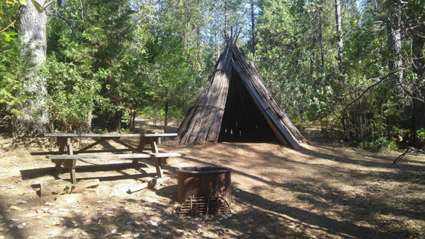
In a dark grove of Incense Cedars at the foot of the landform, close to where Summit City Creek joins the river, there is an astonishing sight: A beautifully made barkhouse. The structure looks just like this, sans the firepit and picnic table:
https://www.parks.ca.gov/pages/553/imag ... nvCamp.jpg
The above photo is from an environmental campground, in a State Park, where you can stay in one of these things.
There was a hush in the forest as I approached the hut. It was clean and neat inside. No signs of life, zo. The only sound was the ceaseless music of the river. And so I sped away, on my moccasined feet, clutching my flintlock. That's what it felt like.
The Mokelumne is a great river.
Sincerely,
Carl Raillard
I was wondering about that trail. That's the one from Grouse Valley, correct? At that point, on my side of the river, there was an established campsite; a clear sign there was a route, over there, that offered some traction. No clear path could be found on the north side of the river. I got lost, trying to puzzle my way around granite bluffs, manzanita thickets, and more poison oak. Some who wander ARE lost!
The walking became easier towards Cedar Camp. Fourth of July Canyon proved to be a difficult ford. (Note, this is another 4th of July Canyon, not the one with the lake, near Round Top.) Furthermore, though,an excellent trail appeared. The thing traveled up and through a notch next to the Kernbut SW of Camp Irene. A brave little trail, but it faded out in the forest, as it approached Irene.
Wandering Daisy again: "I do wish there were a trail in the canyon because it is a very beautiful river."
Indeed it is. The nine mile length between Highway 4, in Hermit Valley, and the mouth of Summit City Creek might interest you. I've attached a jpg. You'll know what to do with it. The first couple of miles westward, from the highway, has a decent trail. As one descends, though, the way gets rougher, the scenery becomes more dramatic, and the tread vanishes. But, honestly, this stretch of the river doesn't need a trail. The worst brush patches can be avoided with some sleuthing work. The granite walls around Jackass Canyon are a treat. The place has a Kings Canyon vibe. The last rocky hill -- a massive Kernbut -- due west of the Wolf cabin is trickiest part of the trip. There's an abundance of massive granite on this landform, and the ravines are choked with brush. No poison oak, though.
In a dark grove of Incense Cedars at the foot of the landform, close to where Summit City Creek joins the river, there is an astonishing sight: A beautifully made barkhouse. The structure looks just like this, sans the firepit and picnic table:
https://www.parks.ca.gov/pages/553/imag ... nvCamp.jpg
The above photo is from an environmental campground, in a State Park, where you can stay in one of these things.
There was a hush in the forest as I approached the hut. It was clean and neat inside. No signs of life, zo. The only sound was the ceaseless music of the river. And so I sped away, on my moccasined feet, clutching my flintlock. That's what it felt like.
The Mokelumne is a great river.
Sincerely,
Carl Raillard
You do not have the required permissions to view the files attached to this post.
Fun drawings of wild country.
-
CarlRaillard
- Topix Acquainted
- Posts: 29
- Joined: Wed Apr 29, 2020 7:54 pm
- Experience: Level 4 Explorer
Re: Mokelumne Wilderness Artmap - trailwork challenge
Balzaccom wrote: " Hope we'll get a chance complete the work this year!"
Balzaccom, do you know about this spot? (the red dot on the attached jpg) It's only a few minutes off the trail. In early season, when water is roaring down the Fourth of July Canyon, you don't want to miss this spot. Even later on, when the water is not high, the place still offers unobstructed views. It's a canyon overlook. So, if you are going to be in this neighborhood again, later this year, you might wish to take a little detour. I'm assuming, of course, you don't know about this spot already.
This is where I laid out my sleeping bag -- next to a juniper -- on the day I regained the cleared trail, the trail you worked on. A trickle of snowmelt provided water. It was good.
Sincerely,
Carl Raillard
You do not have the required permissions to view the files attached to this post.
Fun drawings of wild country.
-
CarlRaillard
- Topix Acquainted
- Posts: 29
- Joined: Wed Apr 29, 2020 7:54 pm
- Experience: Level 4 Explorer
Re: Mokelumne Wilderness Artmap - trailwork challenge
Oh, a fellow forum user called mokelumnekid (appropriate name) has a post with a video showing the river. This is another video from a kayaker's point of view:
http://www.highsierratopix.com/communit ... =7&t=11553
Check it out!
Sincerely,
Carl Raillard
http://www.highsierratopix.com/communit ... =7&t=11553
Check it out!
Sincerely,
Carl Raillard
Fun drawings of wild country.
-
balzaccom
- Topix Addict
- Posts: 2969
- Joined: Wed Dec 17, 2008 9:22 pm
- Experience: N/A
Re: Mokelumne Wilderness Artmap - trailwork challenge
Carl: I know that spot---we checked it out during the trail crew work.
And Daisy, that was one of the first backpacking trips I ever did, back in high school...1969?
And Daisy, that was one of the first backpacking trips I ever did, back in high school...1969?
Check our our website: http://www.backpackthesierra.com/
Or just read a good mystery novel set in the Sierra; https://www.amazon.com/Danger-Falling-R ... 0984884963
Or just read a good mystery novel set in the Sierra; https://www.amazon.com/Danger-Falling-R ... 0984884963
Who is online
Users browsing this forum: No registered users and 165 guests