2022 River/Stream Crossing Reports
-
maverick

- Forums Moderator

- Posts: 11845
- Joined: Thu Apr 06, 2006 5:54 pm
- Experience: Level 4 Explorer
2022 River/Stream Crossing Reports
We'd appreciate any and all reports (with photos if you have them) of river and stream crossing conditions in the Sierra. Please include name of stream, creek, or river crossed, and the date, in the Subject Title.
Last edited by copeg on Sun Mar 26, 2023 4:30 pm, edited 2 times in total.
Reason: Unsticky
Reason: Unsticky
Professional Sierra Landscape Photographer
I don't give out specific route information, my belief is that it takes away from the whole adventure spirit of a trip, if you need every inch planned out, you'll have to get that from someone else.
Have a safer backcountry experience by using the HST ReConn Form 2.0, named after Larry Conn, a HST member: http://reconn.org
-
randydarden

- Topix Novice
- Posts: 5
- Joined: Sun Nov 17, 2019 9:47 pm
- Experience: Level 3 Backpacker
- Location: Oakland, California
- Contact:
Lake Eleanor and Kibbie Lake April 17-19
Crossed Kibbie Creek and an unnamed tributary to its east on a round trip from Lake Eleanor to and from Kibbie Creek. I took the unnamed easternmost trail on the way there (38.012072, -119.864288) and the crossing was pretty intense at 11am: water up to my thighs, fast-moving but in my opinion OK if you've got some experience and trekking poles. Video: https://photos.app.goo.gl/muFVeWnAJdgHqQKW7
I took the western trail back to the Kibbie Ridge Trailhead and that crossing (38.042583, -119.853754) was easier: about 18 inches deep though still fast-moving.
These trails also have a number of underwater portions, about 3-8 inches deep.
I took the western trail back to the Kibbie Ridge Trailhead and that crossing (38.042583, -119.853754) was easier: about 18 inches deep though still fast-moving.
These trails also have a number of underwater portions, about 3-8 inches deep.
-
kpeter

- Topix Fanatic
- Posts: 1450
- Joined: Mon Jan 04, 2010 1:11 pm
- Experience: Level 3 Backpacker
Re: 2022 River/Stream Crossing Reports
I just called the Summit Ranger Station to find out anything about the crossing of W Fork Cherry Creek in Emigrant. They said someone had come out yesterday who had managed the crossing but said it was running high. Snow around Jewel and Deer Lakes, he said.
If anyone crosses W Fork Cherry Creek in the next few days please chime in, I am trying to determine if I and my brother can manage it next week, or whether we should change destinations.
If anyone crosses W Fork Cherry Creek in the next few days please chime in, I am trying to determine if I and my brother can manage it next week, or whether we should change destinations.
-
Wandering Daisy

- Topix Docent
- Posts: 6693
- Joined: Sun Jan 24, 2010 8:19 pm
- Experience: N/A
- Location: Fair Oaks CA (Sacramento area)
- Contact:
Re: 2022 River/Stream Crossing Reports
check out the new post in "conditions", above.
-
frozenintime
- Topix Regular
- Posts: 299
- Joined: Tue Aug 18, 2015 8:06 pm
- Experience: N/A
Re: 2022 River/Stream Crossing Reports
whoops, i also just posted in the conditions page about crossing w fork cherry (via bourland, however). someone could move it here if that's better? my bad.
-
kpeter
- Topix Fanatic
- Posts: 1450
- Joined: Mon Jan 04, 2010 1:11 pm
- Experience: Level 3 Backpacker
Lily, Pauite, West Fork Cherry Creeks 5/30-6/3
West Emigrant Crossings May 30-June 3.
Lily and Paiute Creeks, on both the high and the low trail were easily fordable, no more than knee deep.
West Fork Cherry creek on the high trail was slightly more than knee high on June 2, cold, slow, sandy bottom, 40' across. Safe but unpleasant only because of the cold.
We crossed West Ford Cherry Creek on the low trail several hundred yards North of the official crossing at a point where the water spreads out after a cascade. It was ankle deep as it sheeted across the granite. Easy and fun. Did not look at the official crossing.
-
Harlen

- Topix Addict
- Posts: 2098
- Joined: Sat Mar 11, 2017 9:13 am
- Experience: Level 4 Explorer
- Location: Santa Cruz Mountains
East Fork Cherry Creek, 5/27-5/29
East Fork Cherry Creek reputedly easy to avoid the first 2 crossings south and then SE of Lord's Meadow, heading upstream from below Styx Pass. Third crossing was said to be dangerous on 5/27 by a solo hiker we met. [photo spot] We all crossed this deep, but slow and easy water of the East Fork of Cherry at the top of Huckleberry Lake on 5/29.
You do not have the required permissions to view the files attached to this post.
Last edited by Harlen on Wed Jun 15, 2022 8:57 pm, edited 1 time in total.
Properly trained, a man can be dog’s best friend.
-
Love the Sierra

- Topix Expert
- Posts: 436
- Joined: Sat Jun 11, 2016 6:32 pm
- Experience: Level 3 Backpacker
Pine Creek on the way to Granite Park from Honeymoon Lake
3 wet crossings, not deep and not wide, about to my knees. (I am short) Water was moving briskly, but not dangerous or hard at all if you picked the right path. We felt poles and wading shoes were a must.
-
Lenier

- Topix Regular
- Posts: 157
- Joined: Fri Jun 21, 2019 10:02 pm
- Experience: Level 3 Backpacker
- Location: Visalia
SFKR Paradise Valley 6/4
Crossed South Fork Kings River at Upper Paradise, water to mid thigh in mid day if crossed at the right spot- just downstream of the bridge, just upstream from the island.
-
shawnterustic

- Topix Acquainted
- Posts: 79
- Joined: Fri May 21, 2021 11:10 am
- Experience: Level 4 Explorer
- Contact:
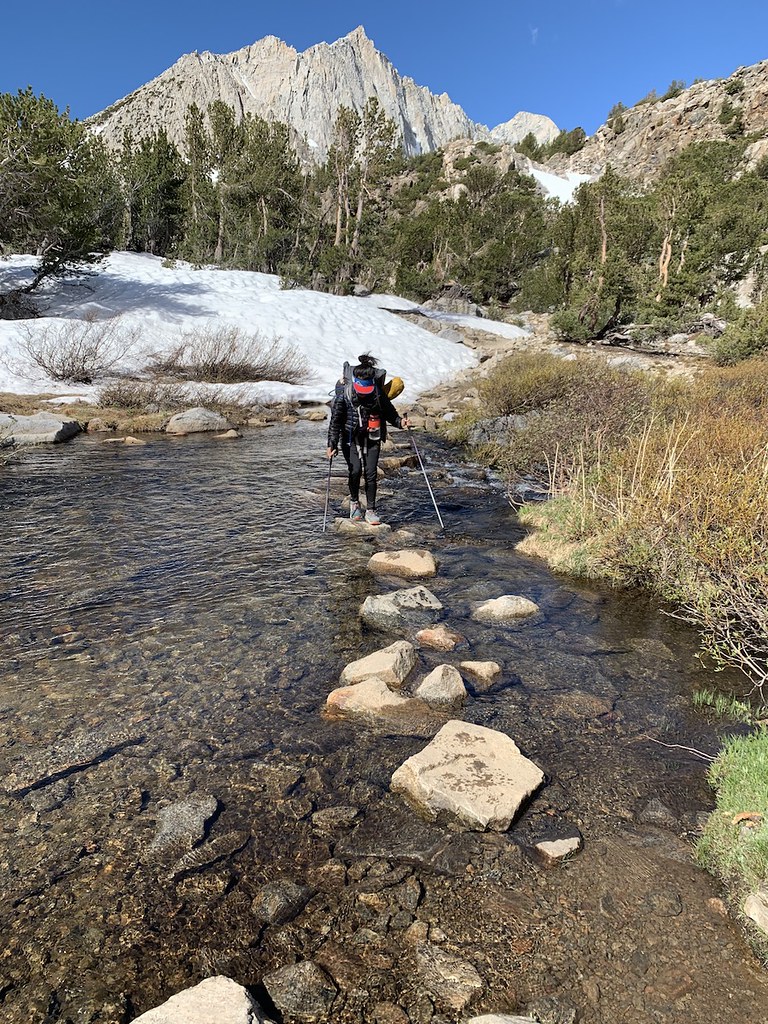
Bishop Pass Trail to Pass 6/10 - 6/12
All water crossings between South Lake and Bishop Pass are navigable over rocks, although folks with shorter legs might get their toes wet on the last big one before Saddlerock / Bishop lakes.
Who is online
Users browsing this forum: No registered users and 4 guests